You are here: Home > Network List > TA - USArray Transportable Network (new EarthScope stations) Stations List
> Station P37A Lathrop, MO, USA > Earthquake Result Viewer
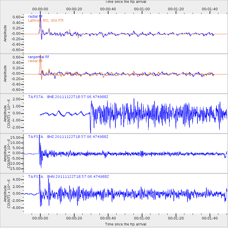
P37A Lathrop, MO, USA - Earthquake Result Viewer
*The percent match for this event was below the threshold and hence no stack was calculated.
| Earthquake location: |
Central Bolivia |
| Earthquake latitude/longitude: |
-15.4/-65.1 |
| Earthquake time(UTC): |
2011/11/22 (326) 18:48:16 GMT |
| Earthquake Depth: |
550 km |
| Earthquake Magnitude: |
6.2 MB, 6.6 MW, 6.6 MW |
| Earthquake Catalog/Contributor: |
WHDF/NEIC |
|
| Network: |
TA USArray Transportable Network (new EarthScope stations) |
| Station: |
P37A Lathrop, MO, USA |
| Lat/Lon: |
39.59 N/94.35 W |
| Elevation: |
300 m |
|
| Distance: |
61.1 deg |
| Az: |
334.444 deg |
| Baz: |
147.413 deg |
| Ray Param: |
$rayparam |
*The percent match for this event was below the threshold and hence was not used in the summary stack. |
|
| Radial Match: |
75.54871 % |
| Radial Bump: |
400 |
| Transverse Match: |
69.5514 % |
| Transverse Bump: |
400 |
| SOD ConfigId: |
432046 |
| Insert Time: |
2012-03-03 05:58:09.769 +0000 |
| GWidth: |
2.5 |
| Max Bumps: |
400 |
| Tol: |
0.001 |
|
Signal To Noise
| Channel | StoN | STA | LTA |
| TA:P37A: :BHZ:20111122T18:57:06.474988Z | 24.393543 | 5.2207683E-6 | 2.1402255E-7 |
| TA:P37A: :BHN:20111122T18:57:06.474988Z | 13.52291 | 1.7210091E-6 | 1.2726618E-7 |
| TA:P37A: :BHE:20111122T18:57:06.474988Z | 6.125878 | 9.85439E-7 | 1.6086494E-7 |
| Arrivals |
| Ps | |
| PpPs | |
| PsPs/PpSs | |


