You are here: Home > Network List > TA - USArray Transportable Network (new EarthScope stations) Stations List
> Station P38A Dawn, MO, USA > Earthquake Result Viewer
P38A Dawn, MO, USA - Earthquake Result Viewer
| Earthquake location: |
Central Bolivia |
| Earthquake latitude/longitude: |
-15.4/-65.1 |
| Earthquake time(UTC): |
2011/11/22 (326) 18:48:16 GMT |
| Earthquake Depth: |
550 km |
| Earthquake Magnitude: |
6.2 MB, 6.6 MW, 6.6 MW |
| Earthquake Catalog/Contributor: |
WHDF/NEIC |
|
| Network: |
TA USArray Transportable Network (new EarthScope stations) |
| Station: |
P38A Dawn, MO, USA |
| Lat/Lon: |
39.62 N/93.53 W |
| Elevation: |
248 m |
|
| Distance: |
60.8 deg |
| Az: |
335.077 deg |
| Baz: |
148.24 deg |
| Ray Param: |
0.059168607 |
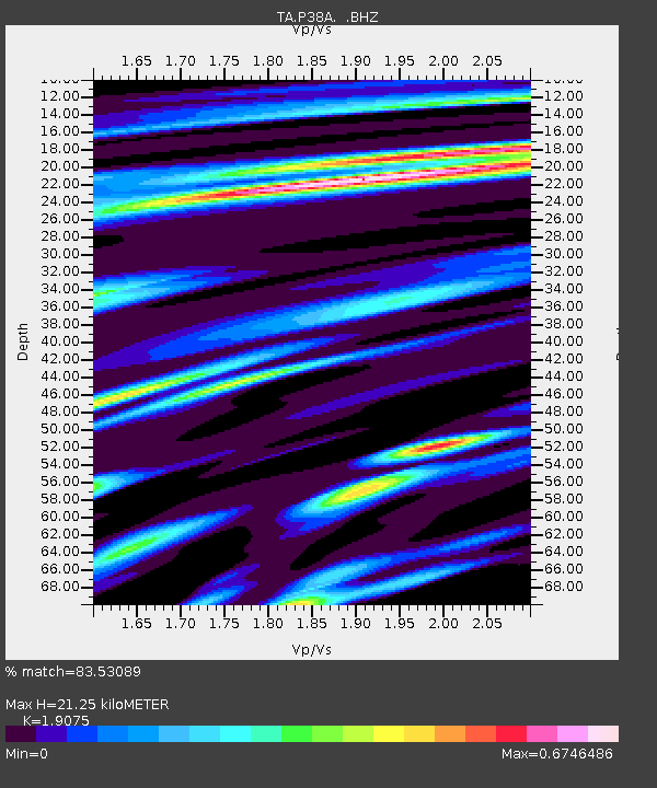
| Estimated Moho Depth: |
21.25 km |
| Estimated Crust Vp/Vs: |
1.91 |
| Assumed Crust Vp: |
6.498 km/s |
| Estimated Crust Vs: |
3.406 km/s |
| Estimated Crust Poisson's Ratio: |
0.31 |
|
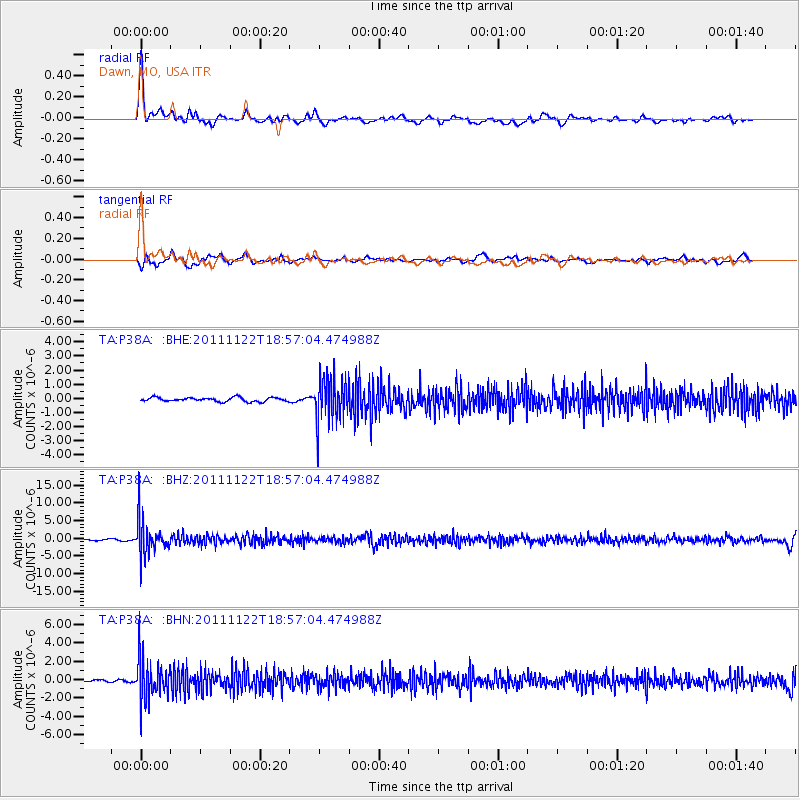
| Radial Match: |
83.53089 % |
| Radial Bump: |
400 |
| Transverse Match: |
53.334347 % |
| Transverse Bump: |
400 |
| SOD ConfigId: |
432046 |
| Insert Time: |
2012-03-03 05:58:21.968 +0000 |
| GWidth: |
2.5 |
| Max Bumps: |
400 |
| Tol: |
0.001 |
|
Signal To Noise
| Channel | StoN | STA | LTA |
| TA:P38A: :BHZ:20111122T18:57:04.474988Z | 33.069725 | 4.9115833E-6 | 1.4852206E-7 |
| TA:P38A: :BHN:20111122T18:57:04.474988Z | 16.115807 | 2.205032E-6 | 1.3682418E-7 |
| TA:P38A: :BHE:20111122T18:57:04.474988Z | 10.562584 | 1.501833E-6 | 1.4218425E-7 |
| Arrivals |
| Ps | 3.1 SECOND |
| PpPs | 9.1 SECOND |
| PsPs/PpSs | 12 SECOND |


