You are here: Home > Network List > TO - Tectonic Observatory Stations List
> Station CC30 CCSE CC30 > Earthquake Result Viewer
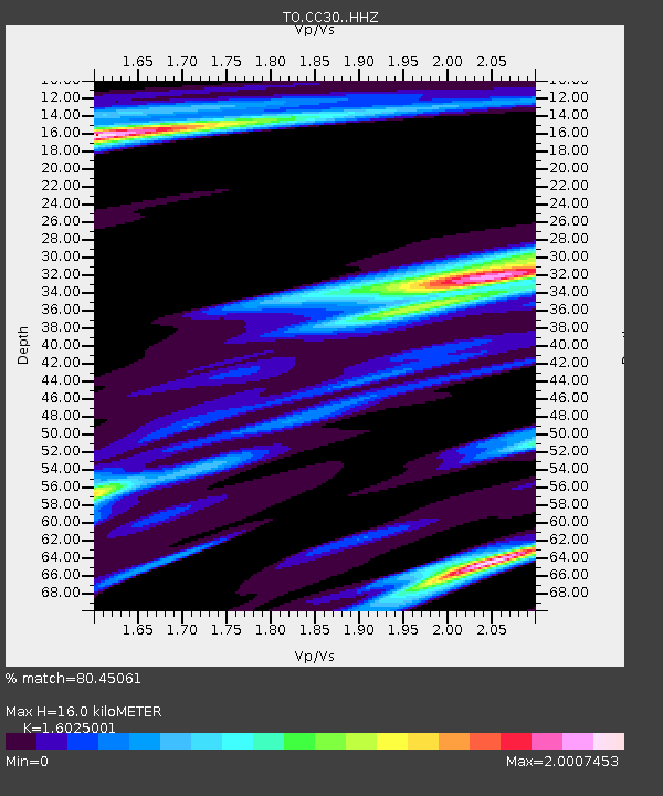
CC30 CCSE CC30 - Earthquake Result Viewer
| Earthquake location: |
Solomon Islands |
| Earthquake latitude/longitude: |
-6.7/155.1 |
| Earthquake time(UTC): |
2014/04/19 (109) 01:04:03 GMT |
| Earthquake Depth: |
24 km |
| Earthquake Magnitude: |
6.6 MWB, 6.9 MI, 7.0 MI |
| Earthquake Catalog/Contributor: |
NEIC PDE/NEIC COMCAT |
|
| Network: |
TO Tectonic Observatory |
| Station: |
CC30 CCSE CC30 |
| Lat/Lon: |
36.31 N/119.34 W |
| Elevation: |
105 m |
|
| Distance: |
90.4 deg |
| Az: |
53.641 deg |
| Baz: |
262.037 deg |
| Ray Param: |
0.04167697 |
| Estimated Moho Depth: |
16.0 km |
| Estimated Crust Vp/Vs: |
1.60 |
| Assumed Crust Vp: |
6.291 km/s |
| Estimated Crust Vs: |
3.926 km/s |
| Estimated Crust Poisson's Ratio: |
0.18 |
|
| Radial Match: |
80.45061 % |
| Radial Bump: |
353 |
| Transverse Match: |
57.27402 % |
| Transverse Bump: |
363 |
| SOD ConfigId: |
3390531 |
| Insert Time: |
2019-04-11 11:49:30.565 +0000 |
| GWidth: |
2.5 |
| Max Bumps: |
400 |
| Tol: |
0.001 |
|

Signal To Noise
| Channel | StoN | STA | LTA |
| TO:CC30: :HHZ:20140419T01:16:30.210002Z | 9.084259 | 1.8036247E-6 | 1.9854396E-7 |
| TO:CC30: :HHN:20140419T01:16:30.210002Z | 1.275265 | 5.642282E-7 | 4.4243995E-7 |
| TO:CC30: :HHE:20140419T01:16:30.210002Z | 2.8208032 | 1.4976071E-6 | 5.3091514E-7 |
| Arrivals |
| Ps | 1.6 SECOND |
| PpPs | 6.5 SECOND |
| PsPs/PpSs | 8.0 SECOND |


