You are here: Home > Network List > YT07 - POLENET Stations List
> Station WHIT WHIT > Earthquake Result Viewer
WHIT WHIT - Earthquake Result Viewer
| Earthquake location: |
Solomon Islands |
| Earthquake latitude/longitude: |
-6.7/155.1 |
| Earthquake time(UTC): |
2014/04/19 (109) 01:04:03 GMT |
| Earthquake Depth: |
24 km |
| Earthquake Magnitude: |
6.6 MWB, 6.9 MI, 7.0 MI |
| Earthquake Catalog/Contributor: |
NEIC PDE/NEIC COMCAT |
|
| Network: |
YT POLENET |
| Station: |
WHIT WHIT |
| Lat/Lon: |
82.68 S/104.39 W |
| Elevation: |
2343 m |
|
| Distance: |
84.8 deg |
| Az: |
172.728 deg |
| Baz: |
258.719 deg |
| Ray Param: |
0.045224454 |
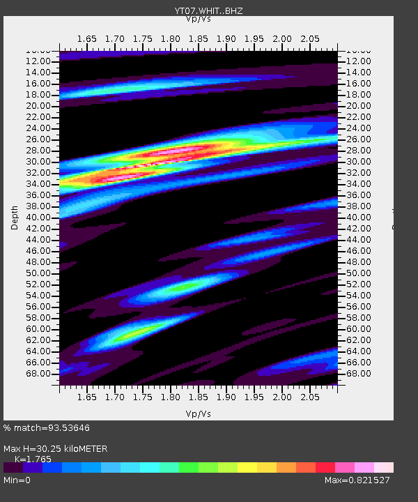
| Estimated Moho Depth: |
30.25 km |
| Estimated Crust Vp/Vs: |
1.76 |
| Assumed Crust Vp: |
6.356 km/s |
| Estimated Crust Vs: |
3.601 km/s |
| Estimated Crust Poisson's Ratio: |
0.26 |
|
| Radial Match: |
93.53646 % |
| Radial Bump: |
400 |
| Transverse Match: |
87.49997 % |
| Transverse Bump: |
400 |
| SOD ConfigId: |
3390531 |
| Insert Time: |
2019-04-11 11:50:27.634 +0000 |
| GWidth: |
2.5 |
| Max Bumps: |
400 |
| Tol: |
0.001 |
|

Signal To Noise
| Channel | StoN | STA | LTA |
| YT:WHIT: :BHZ:20140419T01:16:03.699993Z | 21.084341 | 2.3827465E-6 | 1.1301024E-7 |
| YT:WHIT: :BHN:20140419T01:16:03.699993Z | 3.2247767 | 3.4148684E-7 | 1.0589472E-7 |
| YT:WHIT: :BHE:20140419T01:16:03.699993Z | 6.6785097 | 7.567983E-7 | 1.13318436E-7 |
| Arrivals |
| Ps | 3.7 SECOND |
| PpPs | 13 SECOND |
| PsPs/PpSs | 17 SECOND |


