You are here: Home > Network List > TA - USArray Transportable Network (new EarthScope stations) Stations List
> Station T44A Benton, MO, USA > Earthquake Result Viewer
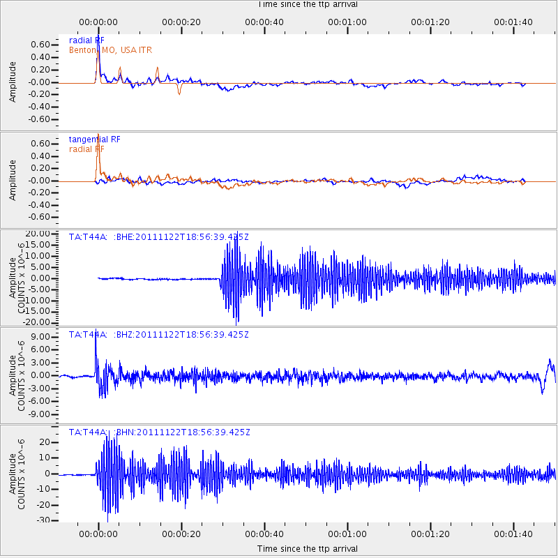
T44A Benton, MO, USA - Earthquake Result Viewer
*The percent match for this event was below the threshold and hence no stack was calculated.
| Earthquake location: |
Central Bolivia |
| Earthquake latitude/longitude: |
-15.4/-65.1 |
| Earthquake time(UTC): |
2011/11/22 (326) 18:48:16 GMT |
| Earthquake Depth: |
550 km |
| Earthquake Magnitude: |
6.2 MB, 6.6 MW, 6.6 MW |
| Earthquake Catalog/Contributor: |
WHDF/NEIC |
|
| Network: |
TA USArray Transportable Network (new EarthScope stations) |
| Station: |
T44A Benton, MO, USA |
| Lat/Lon: |
37.09 N/89.59 W |
| Elevation: |
133 m |
|
| Distance: |
57.1 deg |
| Az: |
336.723 deg |
| Baz: |
151.527 deg |
| Ray Param: |
$rayparam |
*The percent match for this event was below the threshold and hence was not used in the summary stack. |
|
| Radial Match: |
72.96213 % |
| Radial Bump: |
400 |
| Transverse Match: |
44.202267 % |
| Transverse Bump: |
400 |
| SOD ConfigId: |
432046 |
| Insert Time: |
2012-03-03 06:08:47.470 +0000 |
| GWidth: |
2.5 |
| Max Bumps: |
400 |
| Tol: |
0.001 |
|
Signal To Noise
| Channel | StoN | STA | LTA |
| TA:T44A: :BHZ:20111122T18:56:39.425Z | 15.221258 | 2.9760379E-6 | 1.9551852E-7 |
| TA:T44A: :BHN:20111122T18:56:39.425Z | 79.868904 | 1.4416483E-5 | 1.8050183E-7 |
| TA:T44A: :BHE:20111122T18:56:39.425Z | 44.00686 | 9.849323E-6 | 2.2381336E-7 |
| Arrivals |
| Ps | |
| PpPs | |
| PsPs/PpSs | |


