You are here: Home > Network List > ZJ12 - Transantarctic Mountains Northern Network Stations List
> Station SAMH East Antarctica > Earthquake Result Viewer
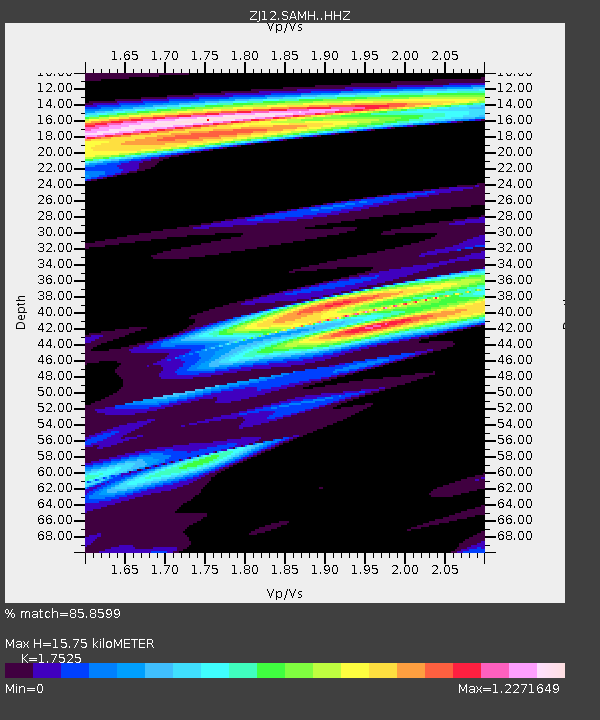
SAMH East Antarctica - Earthquake Result Viewer
| Earthquake location: |
Solomon Islands |
| Earthquake latitude/longitude: |
-6.7/155.1 |
| Earthquake time(UTC): |
2014/04/19 (109) 01:04:03 GMT |
| Earthquake Depth: |
24 km |
| Earthquake Magnitude: |
6.6 MWB, 6.9 MI, 7.0 MI |
| Earthquake Catalog/Contributor: |
NEIC PDE/NEIC COMCAT |
|
| Network: |
ZJ Transantarctic Mountains Northern Network |
| Station: |
SAMH East Antarctica |
| Lat/Lon: |
75.20 S/154.00 E |
| Elevation: |
2087 m |
|
| Distance: |
68.5 deg |
| Az: |
180.301 deg |
| Baz: |
1.162 deg |
| Ray Param: |
0.056248203 |
| Estimated Moho Depth: |
15.75 km |
| Estimated Crust Vp/Vs: |
1.75 |
| Assumed Crust Vp: |
6.262 km/s |
| Estimated Crust Vs: |
3.573 km/s |
| Estimated Crust Poisson's Ratio: |
0.26 |
|
| Radial Match: |
85.8599 % |
| Radial Bump: |
400 |
| Transverse Match: |
79.150154 % |
| Transverse Bump: |
400 |
| SOD ConfigId: |
3390531 |
| Insert Time: |
2019-04-11 11:50:43.988 +0000 |
| GWidth: |
2.5 |
| Max Bumps: |
400 |
| Tol: |
0.001 |
|

Signal To Noise
| Channel | StoN | STA | LTA |
| ZJ:SAMH: :HHZ:20140419T01:14:32.090007Z | 9.107768 | 3.5296957E-6 | 3.8754783E-7 |
| ZJ:SAMH: :HHN:20140419T01:14:32.090007Z | 4.384913 | 1.7844825E-6 | 4.069596E-7 |
| ZJ:SAMH: :HHE:20140419T01:14:32.090007Z | 1.0643919 | 6.1452386E-7 | 5.773474E-7 |
| Arrivals |
| Ps | 2.0 SECOND |
| PpPs | 6.7 SECOND |
| PsPs/PpSs | 8.6 SECOND |


