You are here: Home > Network List > TA - USArray Transportable Network (new EarthScope stations) Stations List
> Station Q41A Truxton, MO, USA > Earthquake Result Viewer
Q41A Truxton, MO, USA - Earthquake Result Viewer
| Earthquake location: |
Central Bolivia |
| Earthquake latitude/longitude: |
-15.4/-65.1 |
| Earthquake time(UTC): |
2011/11/22 (326) 18:48:16 GMT |
| Earthquake Depth: |
550 km |
| Earthquake Magnitude: |
6.2 MB, 6.6 MW, 6.6 MW |
| Earthquake Catalog/Contributor: |
WHDF/NEIC |
|
| Network: |
TA USArray Transportable Network (new EarthScope stations) |
| Station: |
Q41A Truxton, MO, USA |
| Lat/Lon: |
38.95 N/91.23 W |
| Elevation: |
191 m |
|
| Distance: |
59.3 deg |
| Az: |
336.454 deg |
| Baz: |
150.378 deg |
| Ray Param: |
0.06008944 |
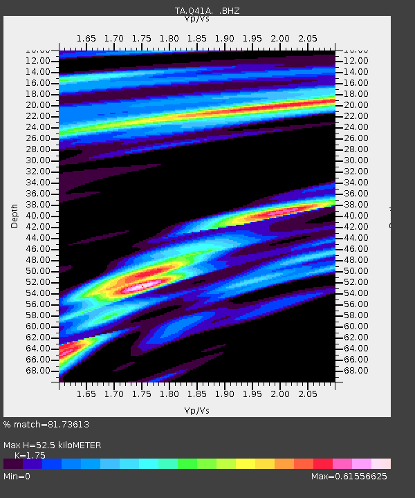
| Estimated Moho Depth: |
52.5 km |
| Estimated Crust Vp/Vs: |
1.75 |
| Assumed Crust Vp: |
6.498 km/s |
| Estimated Crust Vs: |
3.713 km/s |
| Estimated Crust Poisson's Ratio: |
0.26 |
|
| Radial Match: |
81.73613 % |
| Radial Bump: |
400 |
| Transverse Match: |
47.955093 % |
| Transverse Bump: |
400 |
| SOD ConfigId: |
432046 |
| Insert Time: |
2012-03-03 06:10:22.830 +0000 |
| GWidth: |
2.5 |
| Max Bumps: |
400 |
| Tol: |
0.001 |
|

Signal To Noise
| Channel | StoN | STA | LTA |
| TA:Q41A: :BHZ:20111122T18:56:54.649976Z | 18.206038 | 2.8607606E-6 | 1.5713253E-7 |
| TA:Q41A: :BHN:20111122T18:56:54.649976Z | 6.9421473 | 9.291557E-7 | 1.3384269E-7 |
| TA:Q41A: :BHE:20111122T18:56:54.649976Z | 5.3837833 | 7.19509E-7 | 1.3364374E-7 |
| Arrivals |
| Ps | 6.3 SECOND |
| PpPs | 21 SECOND |
| PsPs/PpSs | 28 SECOND |


