You are here: Home > Network List > TA - USArray Transportable Network (new EarthScope stations) Stations List
> Station H41A Junction City, WI, USA > Earthquake Result Viewer
H41A Junction City, WI, USA - Earthquake Result Viewer
| Earthquake location: |
Central Bolivia |
| Earthquake latitude/longitude: |
-15.4/-65.1 |
| Earthquake time(UTC): |
2011/11/22 (326) 18:48:16 GMT |
| Earthquake Depth: |
550 km |
| Earthquake Magnitude: |
6.2 MB, 6.6 MW, 6.6 MW |
| Earthquake Catalog/Contributor: |
WHDF/NEIC |
|
| Network: |
TA USArray Transportable Network (new EarthScope stations) |
| Station: |
H41A Junction City, WI, USA |
| Lat/Lon: |
44.62 N/89.65 W |
| Elevation: |
348 m |
|
| Distance: |
63.7 deg |
| Az: |
340.669 deg |
| Baz: |
153.439 deg |
| Ray Param: |
0.05733131 |
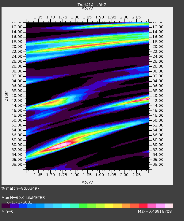
| Estimated Moho Depth: |
60.0 km |
| Estimated Crust Vp/Vs: |
1.74 |
| Assumed Crust Vp: |
6.41 km/s |
| Estimated Crust Vs: |
3.689 km/s |
| Estimated Crust Poisson's Ratio: |
0.25 |
|
| Radial Match: |
80.03497 % |
| Radial Bump: |
400 |
| Transverse Match: |
64.14071 % |
| Transverse Bump: |
400 |
| SOD ConfigId: |
432046 |
| Insert Time: |
2012-03-03 06:10:51.844 +0000 |
| GWidth: |
2.5 |
| Max Bumps: |
400 |
| Tol: |
0.001 |
|
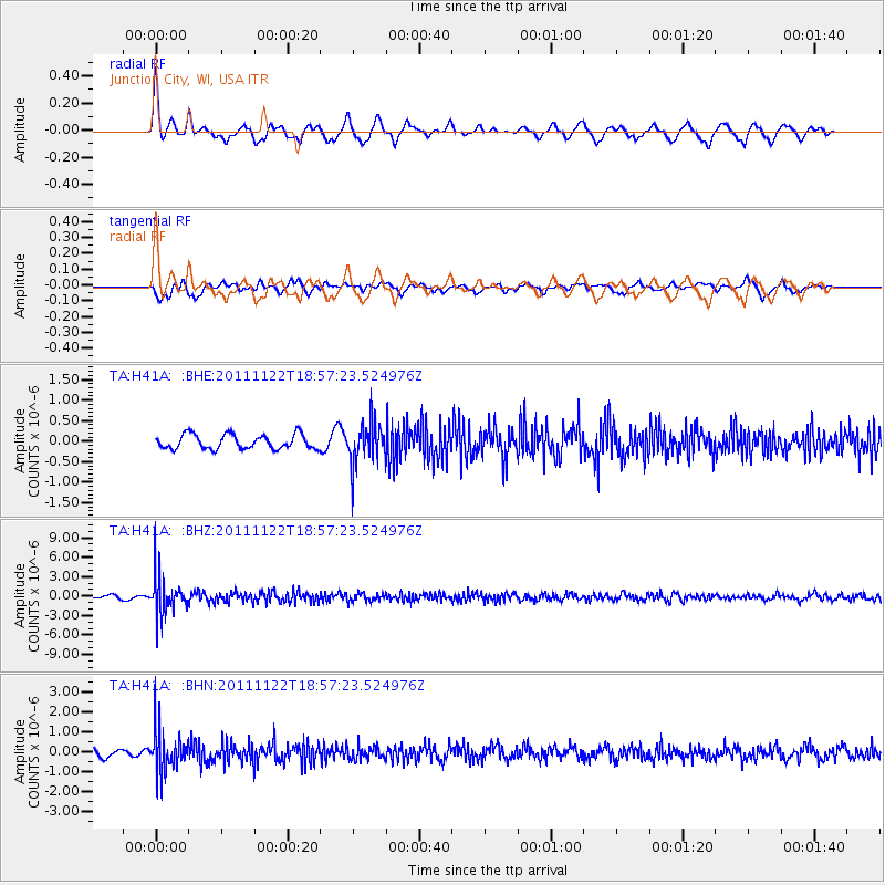
Signal To Noise
| Channel | StoN | STA | LTA |
| TA:H41A: :BHZ:20111122T18:57:23.524976Z | 15.155191 | 2.9759756E-6 | 1.9636674E-7 |
| TA:H41A: :BHN:20111122T18:57:23.524976Z | 6.1922684 | 1.0676234E-6 | 1.7241233E-7 |
| TA:H41A: :BHE:20111122T18:57:23.524976Z | 2.9168537 | 5.0689744E-7 | 1.7378225E-7 |
| Arrivals |
| Ps | 7.2 SECOND |
| PpPs | 25 SECOND |
| PsPs/PpSs | 32 SECOND |


