You are here: Home > Network List > TA - USArray Transportable Network (new EarthScope stations) Stations List
> Station J43A Natural Harvest Farm, Hartford, WI, USA > Earthquake Result Viewer
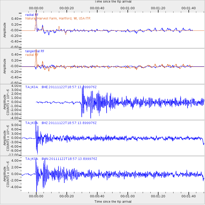
J43A Natural Harvest Farm, Hartford, WI, USA - Earthquake Result Viewer
| Earthquake location: |
Central Bolivia |
| Earthquake latitude/longitude: |
-15.4/-65.1 |
| Earthquake time(UTC): |
2011/11/22 (326) 18:48:16 GMT |
| Earthquake Depth: |
550 km |
| Earthquake Magnitude: |
6.2 MB, 6.6 MW, 6.6 MW |
| Earthquake Catalog/Contributor: |
WHDF/NEIC |
|
| Network: |
TA USArray Transportable Network (new EarthScope stations) |
| Station: |
J43A Natural Harvest Farm, Hartford, WI, USA |
| Lat/Lon: |
43.38 N/88.42 W |
| Elevation: |
322 m |
|
| Distance: |
62.2 deg |
| Az: |
340.958 deg |
| Baz: |
154.425 deg |
| Ray Param: |
0.05827174 |
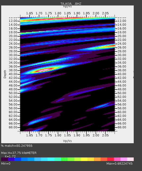
| Estimated Moho Depth: |
37.75 km |
| Estimated Crust Vp/Vs: |
1.72 |
| Assumed Crust Vp: |
6.571 km/s |
| Estimated Crust Vs: |
3.82 km/s |
| Estimated Crust Poisson's Ratio: |
0.24 |
|
| Radial Match: |
80.247955 % |
| Radial Bump: |
400 |
| Transverse Match: |
40.359932 % |
| Transverse Bump: |
400 |
| SOD ConfigId: |
432046 |
| Insert Time: |
2012-03-03 06:13:37.714 +0000 |
| GWidth: |
2.5 |
| Max Bumps: |
400 |
| Tol: |
0.001 |
|
Signal To Noise
| Channel | StoN | STA | LTA |
| TA:J43A: :BHZ:20111122T18:57:13.899976Z | 15.358846 | 4.104066E-6 | 2.6721187E-7 |
| TA:J43A: :BHN:20111122T18:57:13.899976Z | 10.356582 | 1.9229967E-6 | 1.8567872E-7 |
| TA:J43A: :BHE:20111122T18:57:13.899976Z | 12.712908 | 1.5335487E-6 | 1.2062927E-7 |
| Arrivals |
| Ps | 4.3 SECOND |
| PpPs | 15 SECOND |
| PsPs/PpSs | 19 SECOND |


