You are here: Home > Network List > UW - Pacific Northwest Regional Seismic Network Stations List
> Station LEBA Lebam, WA, USA > Earthquake Result Viewer
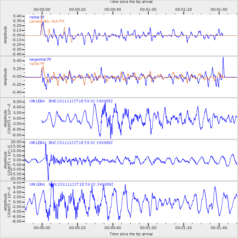
LEBA Lebam, WA, USA - Earthquake Result Viewer
*The percent match for this event was below the threshold and hence no stack was calculated.
| Earthquake location: |
Central Bolivia |
| Earthquake latitude/longitude: |
-15.4/-65.1 |
| Earthquake time(UTC): |
2011/11/22 (326) 18:48:16 GMT |
| Earthquake Depth: |
550 km |
| Earthquake Magnitude: |
6.2 MB, 6.6 MW, 6.6 MW |
| Earthquake Catalog/Contributor: |
WHDF/NEIC |
|
| Network: |
UW Pacific Northwest Regional Seismic Network |
| Station: |
LEBA Lebam, WA, USA |
| Lat/Lon: |
46.55 N/123.56 W |
| Elevation: |
73 m |
|
| Distance: |
80.9 deg |
| Az: |
323.432 deg |
| Baz: |
123.62 deg |
| Ray Param: |
$rayparam |
*The percent match for this event was below the threshold and hence was not used in the summary stack. |
|
| Radial Match: |
52.52709 % |
| Radial Bump: |
317 |
| Transverse Match: |
67.9311 % |
| Transverse Bump: |
394 |
| SOD ConfigId: |
432046 |
| Insert Time: |
2012-03-03 06:17:14.215 +0000 |
| GWidth: |
2.5 |
| Max Bumps: |
400 |
| Tol: |
0.001 |
|
Signal To Noise
| Channel | StoN | STA | LTA |
| UW:LEBA: :BHZ:20111122T18:59:02.349988Z | 6.8145385 | 7.694805E-6 | 1.129175E-6 |
| UW:LEBA: :BHN:20111122T18:59:02.349988Z | 1.9285916 | 3.6309991E-6 | 1.8827205E-6 |
| UW:LEBA: :BHE:20111122T18:59:02.349988Z | 2.6714168 | 5.546735E-6 | 2.076327E-6 |
| Arrivals |
| Ps | |
| PpPs | |
| PsPs/PpSs | |


