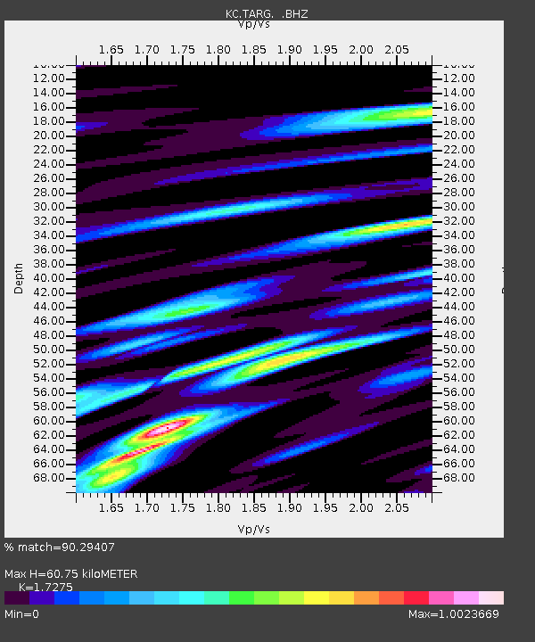
TARG Taragai, Kyrgyzstan - Earthquake Result Viewer

Earthquake location: Near East Coast Of Honshu, Japan
Earthquake latitude/longitude: 37.4/141.4
Earthquake time(UTC): 2011/11/23 (327) 19:24:31 GMT
Earthquake Depth: 34 km
Earthquake Magnitude: 5.7 MB, 5.8 MS, 6.1 MW, 6.1 MW
Earthquake Catalog/Contributor: WHDF/NEIC
Network: KC Central Asian Seismic Network of CAIAG
Station: TARG Taragai, Kyrgyzstan
Lat/Lon: 41.73 N/77.80 E
Elevation: 3530 m
Distance: 48.2 deg
Az: 296.004 deg
Baz: 73.073 deg
Ray Param: 0.069433205
Estimated Moho Depth: 60.75 km
Estimated Crust Vp/Vs: 1.73
Assumed Crust Vp: 6.491 km/s
Estimated Crust Vs: 3.757 km/s
Estimated Crust Poisson's Ratio: 0.25
Radial Match: 90.29407 %
Radial Bump: 400
Transverse Match: 86.88618 %
Transverse Bump: 400
SOD ConfigId: 432046
Insert Time: 2012-03-03 06:33:27.760 +0000
GWidth: 2.5
Max Bumps: 400
Tol: 0.001

Signal To Noise

ChannelStoNSTALTA
KC:TARG: :BHZ:20111123T19:32:38.295012Z17.7739491.420594E-67.992563E-8
KC:TARG: :BHN:20111123T19:32:38.295012Z11.9707125.55372E-74.6394238E-8
KC:TARG: :BHE:20111123T19:32:38.295012Z12.595686.615301E-75.2520395E-8
Arrivals
Ps7.3 SECOND
PpPs24 SECOND
PsPs/PpSs31 SECOND