You are here: Home > Network List > KN - Kyrgyz Seismic Telemetry Network Stations List
> Station KZA KN.KZA > Earthquake Result Viewer
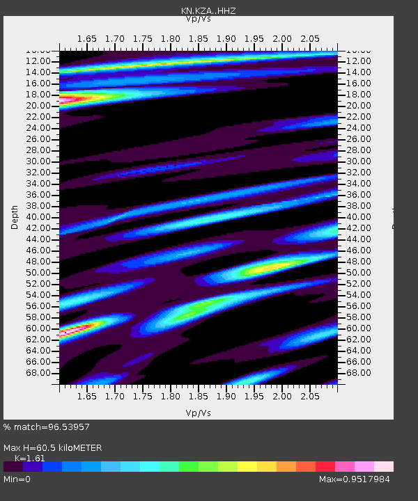
KZA KN.KZA - Earthquake Result Viewer
| Earthquake location: |
Solomon Islands |
| Earthquake latitude/longitude: |
-6.7/154.9 |
| Earthquake time(UTC): |
2014/04/19 (109) 13:27:59 GMT |
| Earthquake Depth: |
31 km |
| Earthquake Magnitude: |
7.5 MWW, 7.8 MI |
| Earthquake Catalog/Contributor: |
NEIC PDE/NEIC COMCAT |
|
| Network: |
KN Kyrgyz Seismic Telemetry Network |
| Station: |
KZA KN.KZA |
| Lat/Lon: |
42.08 N/75.25 E |
| Elevation: |
3520 m |
|
| Distance: |
86.9 deg |
| Az: |
312.817 deg |
| Baz: |
101.866 deg |
| Ray Param: |
0.043707147 |
| Estimated Moho Depth: |
60.5 km |
| Estimated Crust Vp/Vs: |
1.61 |
| Assumed Crust Vp: |
6.306 km/s |
| Estimated Crust Vs: |
3.917 km/s |
| Estimated Crust Poisson's Ratio: |
0.19 |
|
| Radial Match: |
96.53957 % |
| Radial Bump: |
400 |
| Transverse Match: |
89.858894 % |
| Transverse Bump: |
400 |
| SOD ConfigId: |
3390531 |
| Insert Time: |
2019-04-11 11:58:06.783 +0000 |
| GWidth: |
2.5 |
| Max Bumps: |
400 |
| Tol: |
0.001 |
|

Signal To Noise
| Channel | StoN | STA | LTA |
| KN:KZA: :HHZ:20140419T13:40:10.109985Z | 20.876816 | 2.2749095E-6 | 1.0896822E-7 |
| KN:KZA: :HHN:20140419T13:40:10.109985Z | 2.466358 | 1.2275284E-7 | 4.9770893E-8 |
| KN:KZA: :HHE:20140419T13:40:10.109985Z | 6.785781 | 5.9705E-7 | 8.798545E-8 |
| Arrivals |
| Ps | 6.0 SECOND |
| PpPs | 24 SECOND |
| PsPs/PpSs | 30 SECOND |


