You are here: Home > Network List > G - GEOSCOPE Stations List
> Station HYB Hyderabad, India > Earthquake Result Viewer
HYB Hyderabad, India - Earthquake Result Viewer
| Earthquake location: |
Ryukyu Islands, Japan |
| Earthquake latitude/longitude: |
27.9/130.3 |
| Earthquake time(UTC): |
1995/10/18 (291) 10:37:26 GMT |
| Earthquake Depth: |
27 km |
| Earthquake Magnitude: |
6.5 MB, 6.8 MS, 6.7 UNKNOWN, 7.1 MW |
| Earthquake Catalog/Contributor: |
WHDF/NEIC |
|
| Network: |
G GEOSCOPE |
| Station: |
HYB Hyderabad, India |
| Lat/Lon: |
17.42 N/78.55 E |
| Elevation: |
510 m |
|
| Distance: |
48.6 deg |
| Az: |
269.095 deg |
| Baz: |
67.933 deg |
| Ray Param: |
0.06920068 |
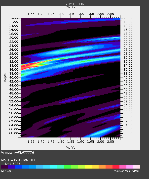
| Estimated Moho Depth: |
35.0 km |
| Estimated Crust Vp/Vs: |
1.65 |
| Assumed Crust Vp: |
6.459 km/s |
| Estimated Crust Vs: |
3.921 km/s |
| Estimated Crust Poisson's Ratio: |
0.21 |
|
| Radial Match: |
95.977776 % |
| Radial Bump: |
217 |
| Transverse Match: |
75.91039 % |
| Transverse Bump: |
400 |
| SOD ConfigId: |
6273 |
| Insert Time: |
2010-02-26 22:53:17.887 +0000 |
| GWidth: |
2.5 |
| Max Bumps: |
400 |
| Tol: |
0.001 |
|

Signal To Noise
| Channel | StoN | STA | LTA |
| G:HYB: :BHN:19951018T10:45:36.800Z | 3.0184321 | 1.9122545E-7 | 6.335257E-8 |
| G:HYB: :BHE:19951018T10:45:36.800Z | 2.2970002 | 2.9244404E-7 | 1.2731563E-7 |
| G:HYB: :BHZ:19951018T10:45:36.800Z | 2.4227324 | 3.0565738E-7 | 1.2616226E-7 |
| Arrivals |
| Ps | 3.7 SECOND |
| PpPs | 13 SECOND |
| PsPs/PpSs | 17 SECOND |


