You are here: Home > Network List > PF - Volcanologic Network of Piton de Fournaise-OVPF Stations List
> Station GBS Grandes pentes coulee 1943 bas > Earthquake Result Viewer
GBS Grandes pentes coulee 1943 bas - Earthquake Result Viewer
| Earthquake location: |
Solomon Islands |
| Earthquake latitude/longitude: |
-6.7/154.9 |
| Earthquake time(UTC): |
2014/04/19 (109) 13:27:59 GMT |
| Earthquake Depth: |
31 km |
| Earthquake Magnitude: |
7.5 MWW, 7.8 MI |
| Earthquake Catalog/Contributor: |
NEIC PDE/NEIC COMCAT |
|
| Network: |
PF Volcanologic Network of Piton de Fournaise-OVPF |
| Station: |
GBS Grandes pentes coulee 1943 bas |
| Lat/Lon: |
21.27 S/55.78 E |
| Elevation: |
471 m |
|
| Distance: |
96.1 deg |
| Az: |
247.814 deg |
| Baz: |
99.575 deg |
| Ray Param: |
0.040606603 |
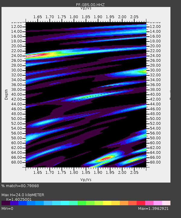
| Estimated Moho Depth: |
24.0 km |
| Estimated Crust Vp/Vs: |
1.60 |
| Assumed Crust Vp: |
4.73 km/s |
| Estimated Crust Vs: |
2.952 km/s |
| Estimated Crust Poisson's Ratio: |
0.18 |
|
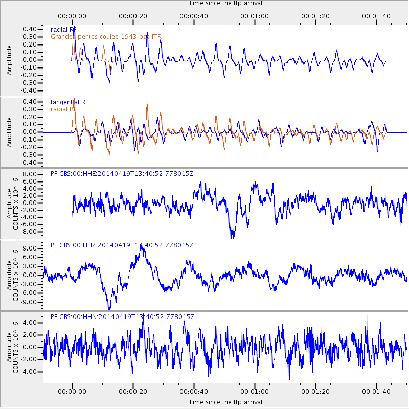
| Radial Match: |
80.79868 % |
| Radial Bump: |
400 |
| Transverse Match: |
49.048893 % |
| Transverse Bump: |
400 |
| SOD ConfigId: |
3390531 |
| Insert Time: |
2019-04-11 11:58:34.349 +0000 |
| GWidth: |
2.5 |
| Max Bumps: |
400 |
| Tol: |
0.001 |
|
Signal To Noise
| Channel | StoN | STA | LTA |
| PF:GBS:00:HHZ:20140419T13:40:52.778015Z | 2.1219122 | 2.0126615E-6 | 9.485131E-7 |
| PF:GBS:00:HHN:20140419T13:40:52.778015Z | 0.8685592 | 1.350019E-6 | 1.5543202E-6 |
| PF:GBS:00:HHE:20140419T13:40:52.778015Z | 0.8550823 | 1.3555117E-6 | 1.5852413E-6 |
| Arrivals |
| Ps | 3.1 SECOND |
| PpPs | 13 SECOND |
| PsPs/PpSs | 16 SECOND |


