You are here: Home > Network List > PS - Pacific21 Stations List
> Station PSI Parapat, Indonesia > Earthquake Result Viewer
PSI Parapat, Indonesia - Earthquake Result Viewer
| Earthquake location: |
Solomon Islands |
| Earthquake latitude/longitude: |
-6.7/154.9 |
| Earthquake time(UTC): |
2014/04/19 (109) 13:27:59 GMT |
| Earthquake Depth: |
31 km |
| Earthquake Magnitude: |
7.5 MWW, 7.8 MI |
| Earthquake Catalog/Contributor: |
NEIC PDE/NEIC COMCAT |
|
| Network: |
PS Pacific21 |
| Station: |
PSI Parapat, Indonesia |
| Lat/Lon: |
2.69 N/98.92 E |
| Elevation: |
987 m |
|
| Distance: |
56.7 deg |
| Az: |
277.653 deg |
| Baz: |
99.787 deg |
| Ray Param: |
0.063927695 |
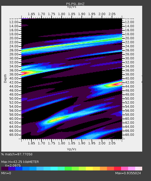
| Estimated Moho Depth: |
42.25 km |
| Estimated Crust Vp/Vs: |
2.10 |
| Assumed Crust Vp: |
6.468 km/s |
| Estimated Crust Vs: |
3.084 km/s |
| Estimated Crust Poisson's Ratio: |
0.35 |
|
| Radial Match: |
97.77058 % |
| Radial Bump: |
400 |
| Transverse Match: |
96.7167 % |
| Transverse Bump: |
400 |
| SOD ConfigId: |
3390531 |
| Insert Time: |
2019-04-11 11:58:47.410 +0000 |
| GWidth: |
2.5 |
| Max Bumps: |
400 |
| Tol: |
0.001 |
|

Signal To Noise
| Channel | StoN | STA | LTA |
| PS:PSI: :BHZ:20140419T13:37:09.911011Z | 76.97637 | 8.9357645E-6 | 1.1608451E-7 |
| PS:PSI: :BHN:20140419T13:37:09.911011Z | 5.9844193 | 6.7679815E-7 | 1.1309337E-7 |
| PS:PSI: :BHE:20140419T13:37:09.911011Z | 38.644726 | 4.055262E-6 | 1.0493701E-7 |
| Arrivals |
| Ps | 7.5 SECOND |
| PpPs | 19 SECOND |
| PsPs/PpSs | 27 SECOND |


