You are here: Home > Network List > TA - USArray Transportable Network (new EarthScope stations) Stations List
> Station J31A Geddes, SD, USA > Earthquake Result Viewer
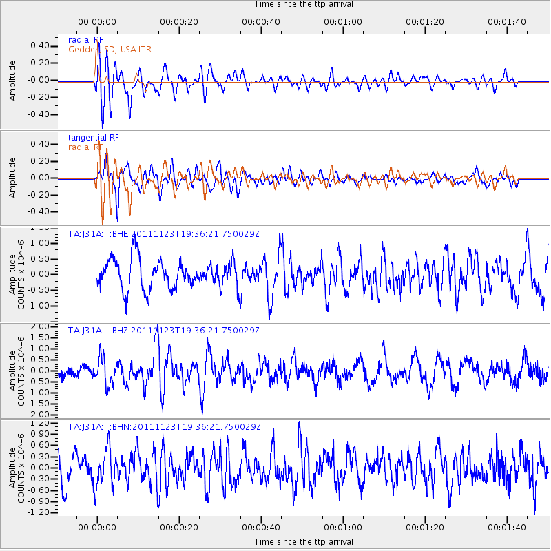
J31A Geddes, SD, USA - Earthquake Result Viewer
*The percent match for this event was below the threshold and hence no stack was calculated.
| Earthquake location: |
Near East Coast Of Honshu, Japan |
| Earthquake latitude/longitude: |
37.4/141.4 |
| Earthquake time(UTC): |
2011/11/23 (327) 19:24:31 GMT |
| Earthquake Depth: |
34 km |
| Earthquake Magnitude: |
5.7 MB, 5.8 MS, 6.1 MW, 6.1 MW |
| Earthquake Catalog/Contributor: |
WHDF/NEIC |
|
| Network: |
TA USArray Transportable Network (new EarthScope stations) |
| Station: |
J31A Geddes, SD, USA |
| Lat/Lon: |
43.29 N/98.74 W |
| Elevation: |
491 m |
|
| Distance: |
82.9 deg |
| Az: |
39.633 deg |
| Baz: |
315.89 deg |
| Ray Param: |
$rayparam |
*The percent match for this event was below the threshold and hence was not used in the summary stack. |
|
| Radial Match: |
76.89731 % |
| Radial Bump: |
400 |
| Transverse Match: |
60.270412 % |
| Transverse Bump: |
400 |
| SOD ConfigId: |
432046 |
| Insert Time: |
2012-03-03 06:41:41.455 +0000 |
| GWidth: |
2.5 |
| Max Bumps: |
400 |
| Tol: |
0.001 |
|
Signal To Noise
| Channel | StoN | STA | LTA |
| TA:J31A: :BHZ:20111123T19:36:21.750029Z | 1.5323533 | 6.0588735E-7 | 3.9539665E-7 |
| TA:J31A: :BHN:20111123T19:36:21.750029Z | 1.1201348 | 5.0053075E-7 | 4.4684862E-7 |
| TA:J31A: :BHE:20111123T19:36:21.750029Z | 0.84523386 | 4.1591258E-7 | 4.92068E-7 |
| Arrivals |
| Ps | |
| PpPs | |
| PsPs/PpSs | |


