You are here: Home > Network List > TA - USArray Transportable Network (new EarthScope stations) Stations List
> Station G32A Webster, SD, USA > Earthquake Result Viewer
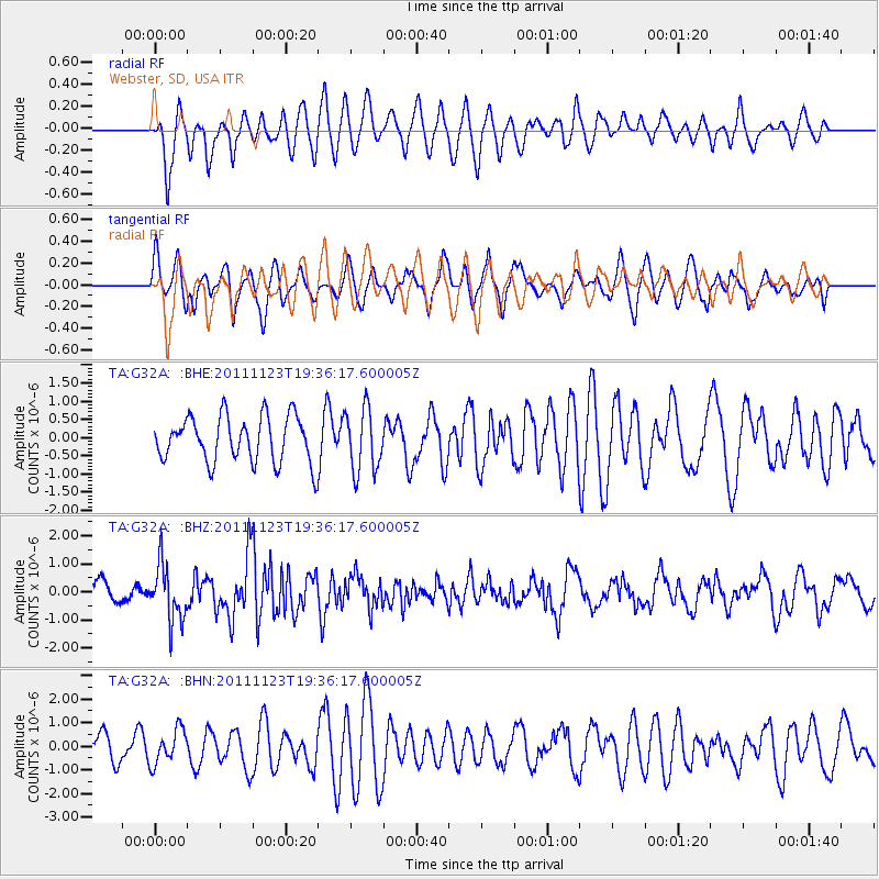
G32A Webster, SD, USA - Earthquake Result Viewer
*The percent match for this event was below the threshold and hence no stack was calculated.
| Earthquake location: |
Near East Coast Of Honshu, Japan |
| Earthquake latitude/longitude: |
37.4/141.4 |
| Earthquake time(UTC): |
2011/11/23 (327) 19:24:31 GMT |
| Earthquake Depth: |
34 km |
| Earthquake Magnitude: |
5.7 MB, 5.8 MS, 6.1 MW, 6.1 MW |
| Earthquake Catalog/Contributor: |
WHDF/NEIC |
|
| Network: |
TA USArray Transportable Network (new EarthScope stations) |
| Station: |
G32A Webster, SD, USA |
| Lat/Lon: |
45.26 N/97.50 W |
| Elevation: |
566 m |
|
| Distance: |
82.1 deg |
| Az: |
37.614 deg |
| Baz: |
316.491 deg |
| Ray Param: |
$rayparam |
*The percent match for this event was below the threshold and hence was not used in the summary stack. |
|
| Radial Match: |
58.31035 % |
| Radial Bump: |
400 |
| Transverse Match: |
52.196037 % |
| Transverse Bump: |
400 |
| SOD ConfigId: |
432046 |
| Insert Time: |
2012-03-03 06:42:53.015 +0000 |
| GWidth: |
2.5 |
| Max Bumps: |
400 |
| Tol: |
0.001 |
|
Signal To Noise
| Channel | StoN | STA | LTA |
| TA:G32A: :BHZ:20111123T19:36:17.600005Z | 3.4164155 | 9.933009E-7 | 2.9074357E-7 |
| TA:G32A: :BHN:20111123T19:36:17.600005Z | 1.0658906 | 7.278777E-7 | 6.828822E-7 |
| TA:G32A: :BHE:20111123T19:36:17.600005Z | 1.3699746 | 8.616402E-7 | 6.2894617E-7 |
| Arrivals |
| Ps | |
| PpPs | |
| PsPs/PpSs | |


