You are here: Home > Network List > TA - USArray Transportable Network (new EarthScope stations) Stations List
> Station I38A Scanlan Farm, Eyota, MN, USA > Earthquake Result Viewer
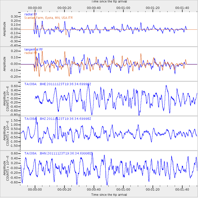
I38A Scanlan Farm, Eyota, MN, USA - Earthquake Result Viewer
*The percent match for this event was below the threshold and hence no stack was calculated.
| Earthquake location: |
Near East Coast Of Honshu, Japan |
| Earthquake latitude/longitude: |
37.4/141.4 |
| Earthquake time(UTC): |
2011/11/23 (327) 19:24:31 GMT |
| Earthquake Depth: |
34 km |
| Earthquake Magnitude: |
5.7 MB, 5.8 MS, 6.1 MW, 6.1 MW |
| Earthquake Catalog/Contributor: |
WHDF/NEIC |
|
| Network: |
TA USArray Transportable Network (new EarthScope stations) |
| Station: |
I38A Scanlan Farm, Eyota, MN, USA |
| Lat/Lon: |
44.04 N/92.33 W |
| Elevation: |
390 m |
|
| Distance: |
85.5 deg |
| Az: |
35.662 deg |
| Baz: |
319.902 deg |
| Ray Param: |
$rayparam |
*The percent match for this event was below the threshold and hence was not used in the summary stack. |
|
| Radial Match: |
62.111088 % |
| Radial Bump: |
400 |
| Transverse Match: |
56.74551 % |
| Transverse Bump: |
400 |
| SOD ConfigId: |
432046 |
| Insert Time: |
2012-03-03 06:43:34.933 +0000 |
| GWidth: |
2.5 |
| Max Bumps: |
400 |
| Tol: |
0.001 |
|
Signal To Noise
| Channel | StoN | STA | LTA |
| TA:I38A: :BHZ:20111123T19:36:34.69998Z | 3.7861989 | 9.433039E-7 | 2.4914274E-7 |
| TA:I38A: :BHN:20111123T19:36:34.69998Z | 0.88713694 | 2.4618288E-7 | 2.775027E-7 |
| TA:I38A: :BHE:20111123T19:36:34.69998Z | 1.3466451 | 3.1785228E-7 | 2.360327E-7 |
| Arrivals |
| Ps | |
| PpPs | |
| PsPs/PpSs | |


