You are here: Home > Network List > TA - USArray Transportable Network (new EarthScope stations) Stations List
> Station E36A McGregor, MN, USA > Earthquake Result Viewer
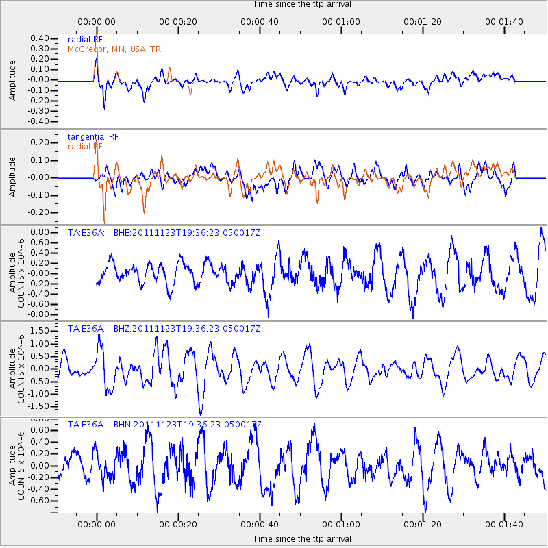
E36A McGregor, MN, USA - Earthquake Result Viewer
*The percent match for this event was below the threshold and hence no stack was calculated.
| Earthquake location: |
Near East Coast Of Honshu, Japan |
| Earthquake latitude/longitude: |
37.4/141.4 |
| Earthquake time(UTC): |
2011/11/23 (327) 19:24:31 GMT |
| Earthquake Depth: |
34 km |
| Earthquake Magnitude: |
5.7 MB, 5.8 MS, 6.1 MW, 6.1 MW |
| Earthquake Catalog/Contributor: |
WHDF/NEIC |
|
| Network: |
TA USArray Transportable Network (new EarthScope stations) |
| Station: |
E36A McGregor, MN, USA |
| Lat/Lon: |
46.52 N/93.26 W |
| Elevation: |
393 m |
|
| Distance: |
83.2 deg |
| Az: |
34.545 deg |
| Baz: |
319.137 deg |
| Ray Param: |
$rayparam |
*The percent match for this event was below the threshold and hence was not used in the summary stack. |
|
| Radial Match: |
62.309036 % |
| Radial Bump: |
400 |
| Transverse Match: |
42.97161 % |
| Transverse Bump: |
400 |
| SOD ConfigId: |
432046 |
| Insert Time: |
2012-03-03 06:43:55.608 +0000 |
| GWidth: |
2.5 |
| Max Bumps: |
400 |
| Tol: |
0.001 |
|
Signal To Noise
| Channel | StoN | STA | LTA |
| TA:E36A: :BHZ:20111123T19:36:23.050017Z | 2.2378325 | 7.861976E-7 | 3.5132098E-7 |
| TA:E36A: :BHN:20111123T19:36:23.050017Z | 0.7555709 | 2.1719575E-7 | 2.8745913E-7 |
| TA:E36A: :BHE:20111123T19:36:23.050017Z | 0.80409133 | 1.5347995E-7 | 1.9087378E-7 |
| Arrivals |
| Ps | |
| PpPs | |
| PsPs/PpSs | |


