You are here: Home > Network List > TA - USArray Transportable Network (new EarthScope stations) Stations List
> Station R38A Fenwick Farm, Montrose, MO, USA > Earthquake Result Viewer
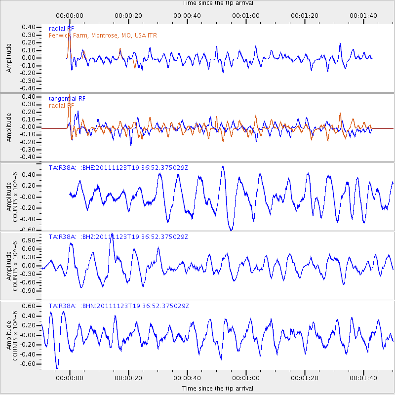
R38A Fenwick Farm, Montrose, MO, USA - Earthquake Result Viewer
*The percent match for this event was below the threshold and hence no stack was calculated.
| Earthquake location: |
Near East Coast Of Honshu, Japan |
| Earthquake latitude/longitude: |
37.4/141.4 |
| Earthquake time(UTC): |
2011/11/23 (327) 19:24:31 GMT |
| Earthquake Depth: |
34 km |
| Earthquake Magnitude: |
5.7 MB, 5.8 MS, 6.1 MW, 6.1 MW |
| Earthquake Catalog/Contributor: |
WHDF/NEIC |
|
| Network: |
TA USArray Transportable Network (new EarthScope stations) |
| Station: |
R38A Fenwick Farm, Montrose, MO, USA |
| Lat/Lon: |
38.19 N/93.91 W |
| Elevation: |
237 m |
|
| Distance: |
89.2 deg |
| Az: |
40.37 deg |
| Baz: |
319.088 deg |
| Ray Param: |
$rayparam |
*The percent match for this event was below the threshold and hence was not used in the summary stack. |
|
| Radial Match: |
58.97681 % |
| Radial Bump: |
400 |
| Transverse Match: |
64.38533 % |
| Transverse Bump: |
390 |
| SOD ConfigId: |
432046 |
| Insert Time: |
2012-03-03 06:45:14.932 +0000 |
| GWidth: |
2.5 |
| Max Bumps: |
400 |
| Tol: |
0.001 |
|
Signal To Noise
| Channel | StoN | STA | LTA |
| TA:R38A: :BHZ:20111123T19:36:52.375029Z | 3.6112826 | 5.34235E-7 | 1.4793498E-7 |
| TA:R38A: :BHN:20111123T19:36:52.375029Z | 0.9671348 | 1.9465475E-7 | 2.0126951E-7 |
| TA:R38A: :BHE:20111123T19:36:52.375029Z | 2.6226168 | 2.960154E-7 | 1.1287025E-7 |
| Arrivals |
| Ps | |
| PpPs | |
| PsPs/PpSs | |


