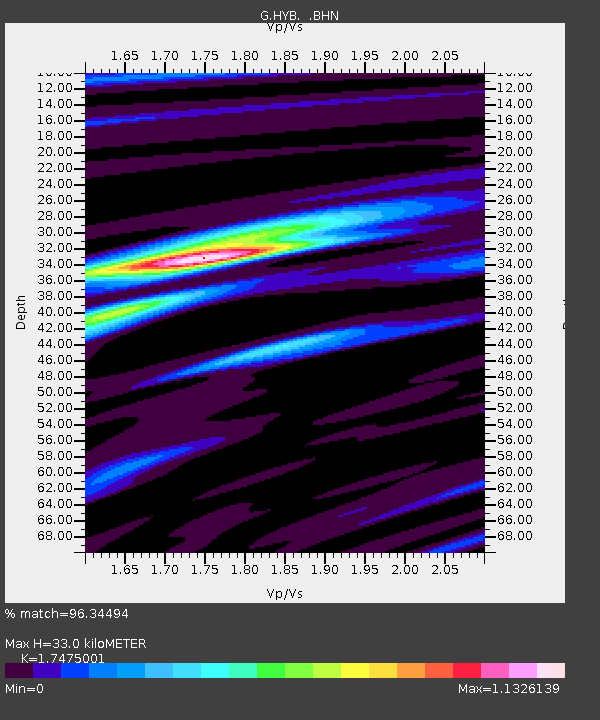
HYB Hyderabad, India - Earthquake Result Viewer

Earthquake location: South Of Sumbawa, Indonesia
Earthquake latitude/longitude: -11.2/118.7
Earthquake time(UTC): 1996/02/12 (043) 09:08:10 GMT
Earthquake Depth: 33 km
Earthquake Magnitude: 5.8 MB, 5.8 MS, 6.1 UNKNOWN, 6.0 MW
Earthquake Catalog/Contributor: WHDF/NEIC
Network: G GEOSCOPE
Station: HYB Hyderabad, India
Lat/Lon: 17.42 N/78.55 E
Elevation: 510 m
Distance: 48.7 deg
Az: 305.106 deg
Baz: 122.765 deg
Ray Param: 0.0690893
Estimated Moho Depth: 33.0 km
Estimated Crust Vp/Vs: 1.75
Assumed Crust Vp: 6.459 km/s
Estimated Crust Vs: 3.696 km/s
Estimated Crust Poisson's Ratio: 0.26
Radial Match: 96.34494 %
Radial Bump: 265
Transverse Match: 78.087456 %
Transverse Bump: 400
SOD ConfigId: 6273
Insert Time: 2010-02-26 22:53:41.652 +0000
GWidth: 2.5
Max Bumps: 400
Tol: 0.001

Signal To Noise

ChannelStoNSTALTA
G:HYB: :BHN:19960212T09:16:21.550012Z1.45673811.504905E-71.0330648E-7
G:HYB: :BHE:19960212T09:16:21.550012Z2.65094161.7212396E-76.492937E-8
G:HYB: :BHZ:19960212T09:16:21.550012Z3.80931043.4149167E-78.964659E-8
Arrivals
Ps4.1 SECOND
PpPs13 SECOND
PsPs/PpSs17 SECOND