You are here: Home > Network List > TA - USArray Transportable Network (new EarthScope stations) Stations List
> Station Y42A Garnett, Star City, AR, USA > Earthquake Result Viewer
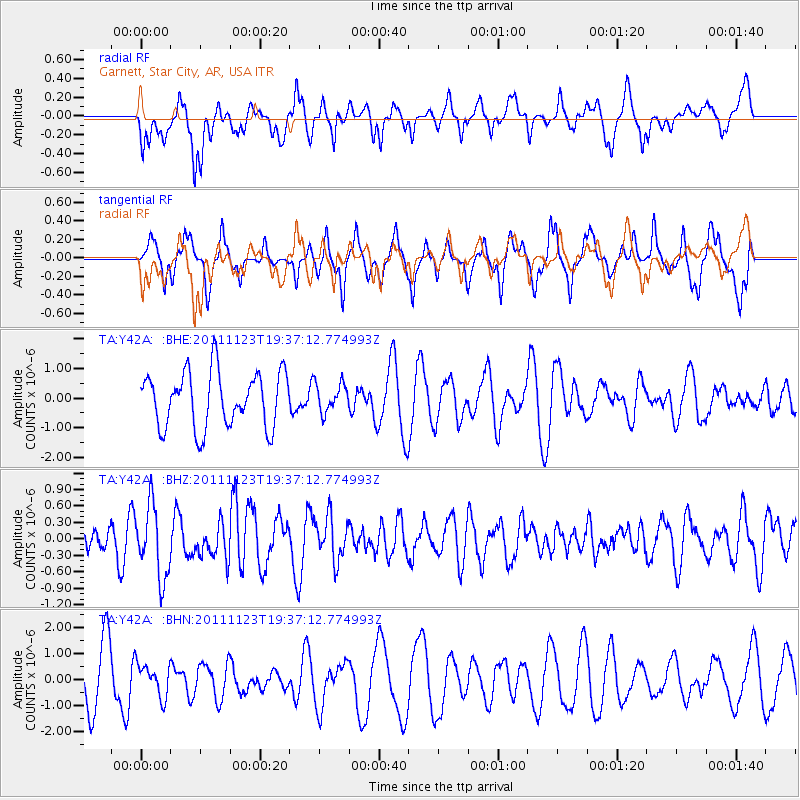
Y42A Garnett, Star City, AR, USA - Earthquake Result Viewer
*The percent match for this event was below the threshold and hence no stack was calculated.
| Earthquake location: |
Near East Coast Of Honshu, Japan |
| Earthquake latitude/longitude: |
37.4/141.4 |
| Earthquake time(UTC): |
2011/11/23 (327) 19:24:31 GMT |
| Earthquake Depth: |
34 km |
| Earthquake Magnitude: |
5.7 MB, 5.8 MS, 6.1 MW, 6.1 MW |
| Earthquake Catalog/Contributor: |
WHDF/NEIC |
|
| Network: |
TA USArray Transportable Network (new EarthScope stations) |
| Station: |
Y42A Garnett, Star City, AR, USA |
| Lat/Lon: |
33.84 N/91.79 W |
| Elevation: |
77 m |
|
| Distance: |
93.6 deg |
| Az: |
41.868 deg |
| Baz: |
320.293 deg |
| Ray Param: |
$rayparam |
*The percent match for this event was below the threshold and hence was not used in the summary stack. |
|
| Radial Match: |
46.91061 % |
| Radial Bump: |
337 |
| Transverse Match: |
43.54514 % |
| Transverse Bump: |
284 |
| SOD ConfigId: |
432046 |
| Insert Time: |
2012-03-03 06:47:07.492 +0000 |
| GWidth: |
2.5 |
| Max Bumps: |
400 |
| Tol: |
0.001 |
|
Signal To Noise
| Channel | StoN | STA | LTA |
| TA:Y42A: :BHZ:20111123T19:37:12.774993Z | 2.708066 | 6.517225E-7 | 2.4065972E-7 |
| TA:Y42A: :BHN:20111123T19:37:12.774993Z | 0.5878057 | 6.231236E-7 | 1.0600843E-6 |
| TA:Y42A: :BHE:20111123T19:37:12.774993Z | 0.5147288 | 4.7858487E-7 | 9.2978064E-7 |
| Arrivals |
| Ps | |
| PpPs | |
| PsPs/PpSs | |


