You are here: Home > Network List > TA - USArray Transportable Network (new EarthScope stations) Stations List
> Station T41A Mountain View, MO, USA > Earthquake Result Viewer
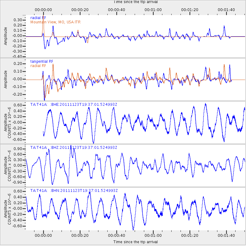
T41A Mountain View, MO, USA - Earthquake Result Viewer
*The percent match for this event was below the threshold and hence no stack was calculated.
| Earthquake location: |
Near East Coast Of Honshu, Japan |
| Earthquake latitude/longitude: |
37.4/141.4 |
| Earthquake time(UTC): |
2011/11/23 (327) 19:24:31 GMT |
| Earthquake Depth: |
34 km |
| Earthquake Magnitude: |
5.7 MB, 5.8 MS, 6.1 MW, 6.1 MW |
| Earthquake Catalog/Contributor: |
WHDF/NEIC |
|
| Network: |
TA USArray Transportable Network (new EarthScope stations) |
| Station: |
T41A Mountain View, MO, USA |
| Lat/Lon: |
37.04 N/91.76 W |
| Elevation: |
366 m |
|
| Distance: |
91.1 deg |
| Az: |
39.809 deg |
| Baz: |
320.392 deg |
| Ray Param: |
$rayparam |
*The percent match for this event was below the threshold and hence was not used in the summary stack. |
|
| Radial Match: |
64.563805 % |
| Radial Bump: |
400 |
| Transverse Match: |
59.76079 % |
| Transverse Bump: |
352 |
| SOD ConfigId: |
432046 |
| Insert Time: |
2012-03-03 06:47:32.802 +0000 |
| GWidth: |
2.5 |
| Max Bumps: |
400 |
| Tol: |
0.001 |
|
Signal To Noise
| Channel | StoN | STA | LTA |
| TA:T41A: :BHZ:20111123T19:37:01.524993Z | 1.6497371 | 6.0016686E-7 | 3.6379544E-7 |
| TA:T41A: :BHN:20111123T19:37:01.524993Z | 1.0034821 | 2.3182758E-7 | 2.3102315E-7 |
| TA:T41A: :BHE:20111123T19:37:01.524993Z | 0.9906936 | 2.8489774E-7 | 2.87574E-7 |
| Arrivals |
| Ps | |
| PpPs | |
| PsPs/PpSs | |


