You are here: Home > Network List > TA - USArray Transportable Network (new EarthScope stations) Stations List
> Station P41A Barry, Barry, IL, USA > Earthquake Result Viewer
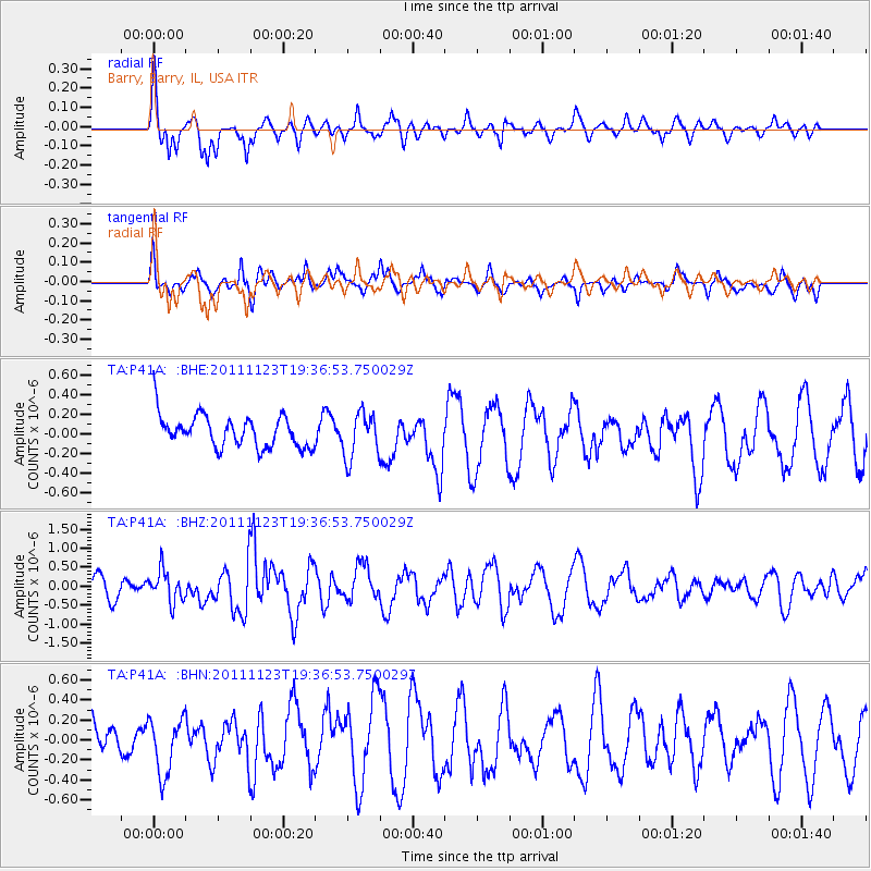
P41A Barry, Barry, IL, USA - Earthquake Result Viewer
*The percent match for this event was below the threshold and hence no stack was calculated.
| Earthquake location: |
Near East Coast Of Honshu, Japan |
| Earthquake latitude/longitude: |
37.4/141.4 |
| Earthquake time(UTC): |
2011/11/23 (327) 19:24:31 GMT |
| Earthquake Depth: |
34 km |
| Earthquake Magnitude: |
5.7 MB, 5.8 MS, 6.1 MW, 6.1 MW |
| Earthquake Catalog/Contributor: |
WHDF/NEIC |
|
| Network: |
TA USArray Transportable Network (new EarthScope stations) |
| Station: |
P41A Barry, Barry, IL, USA |
| Lat/Lon: |
39.67 N/91.06 W |
| Elevation: |
215 m |
|
| Distance: |
89.5 deg |
| Az: |
37.716 deg |
| Baz: |
320.837 deg |
| Ray Param: |
$rayparam |
*The percent match for this event was below the threshold and hence was not used in the summary stack. |
|
| Radial Match: |
70.772484 % |
| Radial Bump: |
334 |
| Transverse Match: |
45.051678 % |
| Transverse Bump: |
363 |
| SOD ConfigId: |
432046 |
| Insert Time: |
2012-03-03 06:48:02.528 +0000 |
| GWidth: |
2.5 |
| Max Bumps: |
400 |
| Tol: |
0.001 |
|
Signal To Noise
| Channel | StoN | STA | LTA |
| TA:P41A: :BHZ:20111123T19:36:53.750029Z | 1.8448187 | 4.129852E-7 | 2.238622E-7 |
| TA:P41A: :BHN:20111123T19:36:53.750029Z | 1.5873452 | 2.7591332E-7 | 1.738206E-7 |
| TA:P41A: :BHE:20111123T19:36:53.750029Z | 1.4190656 | 2.2907471E-7 | 1.6142644E-7 |
| Arrivals |
| Ps | |
| PpPs | |
| PsPs/PpSs | |


