You are here: Home > Network List > TA - USArray Transportable Network (new EarthScope stations) Stations List
> Station R42A Luebbering, MO, USA > Earthquake Result Viewer
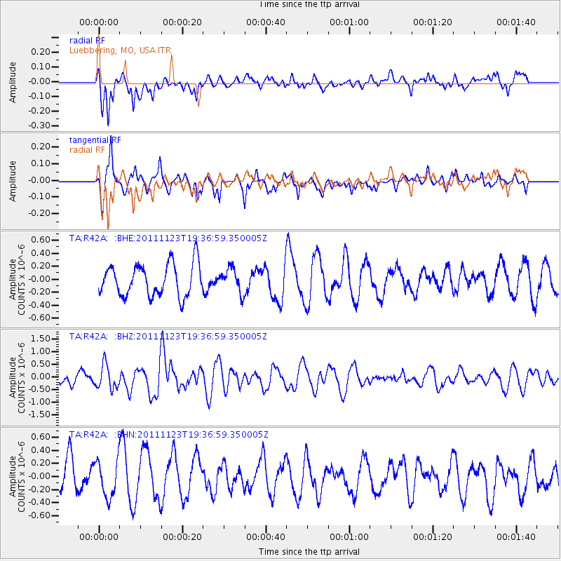
R42A Luebbering, MO, USA - Earthquake Result Viewer
*The percent match for this event was below the threshold and hence no stack was calculated.
| Earthquake location: |
Near East Coast Of Honshu, Japan |
| Earthquake latitude/longitude: |
37.4/141.4 |
| Earthquake time(UTC): |
2011/11/23 (327) 19:24:31 GMT |
| Earthquake Depth: |
34 km |
| Earthquake Magnitude: |
5.7 MB, 5.8 MS, 6.1 MW, 6.1 MW |
| Earthquake Catalog/Contributor: |
WHDF/NEIC |
|
| Network: |
TA USArray Transportable Network (new EarthScope stations) |
| Station: |
R42A Luebbering, MO, USA |
| Lat/Lon: |
38.28 N/90.79 W |
| Elevation: |
218 m |
|
| Distance: |
90.7 deg |
| Az: |
38.432 deg |
| Baz: |
321.003 deg |
| Ray Param: |
$rayparam |
*The percent match for this event was below the threshold and hence was not used in the summary stack. |
|
| Radial Match: |
50.569542 % |
| Radial Bump: |
400 |
| Transverse Match: |
58.22443 % |
| Transverse Bump: |
373 |
| SOD ConfigId: |
432046 |
| Insert Time: |
2012-03-03 06:49:05.783 +0000 |
| GWidth: |
2.5 |
| Max Bumps: |
400 |
| Tol: |
0.001 |
|
Signal To Noise
| Channel | StoN | STA | LTA |
| TA:R42A: :BHZ:20111123T19:36:59.350005Z | 1.8758591 | 4.790628E-7 | 2.5538316E-7 |
| TA:R42A: :BHN:20111123T19:36:59.350005Z | 1.4157504 | 2.871291E-7 | 2.0281054E-7 |
| TA:R42A: :BHE:20111123T19:36:59.350005Z | 0.7745197 | 1.903565E-7 | 2.457736E-7 |
| Arrivals |
| Ps | |
| PpPs | |
| PsPs/PpSs | |


