You are here: Home > Network List > YT07 - POLENET Stations List
> Station MILR MILR > Earthquake Result Viewer
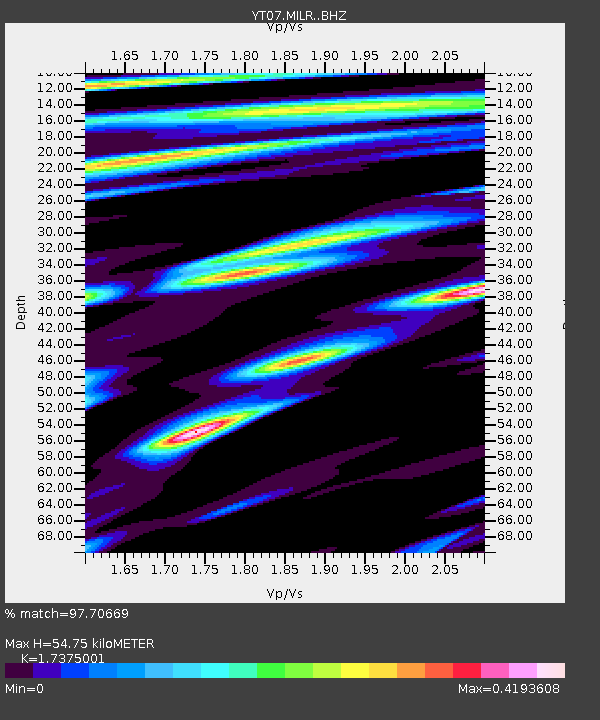
MILR MILR - Earthquake Result Viewer
| Earthquake location: |
Solomon Islands |
| Earthquake latitude/longitude: |
-6.7/154.9 |
| Earthquake time(UTC): |
2014/04/19 (109) 13:27:59 GMT |
| Earthquake Depth: |
31 km |
| Earthquake Magnitude: |
7.5 MWW, 7.8 MI |
| Earthquake Catalog/Contributor: |
NEIC PDE/NEIC COMCAT |
|
| Network: |
YT POLENET |
| Station: |
MILR MILR |
| Lat/Lon: |
83.31 S/156.25 E |
| Elevation: |
1901 m |
|
| Distance: |
76.6 deg |
| Az: |
179.841 deg |
| Baz: |
358.652 deg |
| Ray Param: |
0.05085169 |
| Estimated Moho Depth: |
54.75 km |
| Estimated Crust Vp/Vs: |
1.74 |
| Assumed Crust Vp: |
6.371 km/s |
| Estimated Crust Vs: |
3.667 km/s |
| Estimated Crust Poisson's Ratio: |
0.25 |
|
| Radial Match: |
97.70669 % |
| Radial Bump: |
301 |
| Transverse Match: |
89.73986 % |
| Transverse Bump: |
400 |
| SOD ConfigId: |
3390531 |
| Insert Time: |
2019-04-11 12:00:05.428 +0000 |
| GWidth: |
2.5 |
| Max Bumps: |
400 |
| Tol: |
0.001 |
|

Signal To Noise
| Channel | StoN | STA | LTA |
| YT:MILR: :BHZ:20140419T13:39:16.150024Z | 16.950228 | 3.2640862E-6 | 1.9256888E-7 |
| YT:MILR: :BHN:20140419T13:39:16.150024Z | 3.7971647 | 1.3999755E-6 | 3.686897E-7 |
| YT:MILR: :BHE:20140419T13:39:16.150024Z | 1.1607271 | 3.203751E-7 | 2.7601243E-7 |
| Arrivals |
| Ps | 6.5 SECOND |
| PpPs | 23 SECOND |
| PsPs/PpSs | 29 SECOND |


