You are here: Home > Network List > G - GEOSCOPE Stations List
> Station HYB Hyderabad, India > Earthquake Result Viewer
HYB Hyderabad, India - Earthquake Result Viewer
| Earthquake location: |
Irian Jaya Region, Indonesia |
| Earthquake latitude/longitude: |
-0.9/136.1 |
| Earthquake time(UTC): |
1996/02/17 (048) 20:18:07 GMT |
| Earthquake Depth: |
33 km |
| Earthquake Magnitude: |
6.0 MB, 6.6 MS, 6.6 UNKNOWN |
| Earthquake Catalog/Contributor: |
WHDF/NEIC |
|
| Network: |
G GEOSCOPE |
| Station: |
HYB Hyderabad, India |
| Lat/Lon: |
17.42 N/78.55 E |
| Elevation: |
510 m |
|
| Distance: |
59.4 deg |
| Az: |
290.763 deg |
| Baz: |
101.682 deg |
| Ray Param: |
0.062126223 |
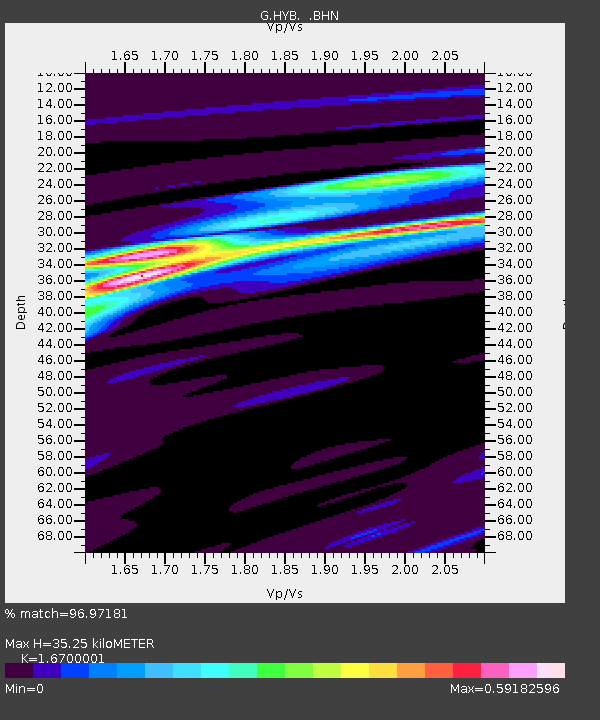
| Estimated Moho Depth: |
35.25 km |
| Estimated Crust Vp/Vs: |
1.67 |
| Assumed Crust Vp: |
6.459 km/s |
| Estimated Crust Vs: |
3.868 km/s |
| Estimated Crust Poisson's Ratio: |
0.22 |
|
| Radial Match: |
96.97181 % |
| Radial Bump: |
180 |
| Transverse Match: |
83.73805 % |
| Transverse Bump: |
400 |
| SOD ConfigId: |
6273 |
| Insert Time: |
2010-02-26 22:53:47.551 +0000 |
| GWidth: |
2.5 |
| Max Bumps: |
400 |
| Tol: |
0.001 |
|
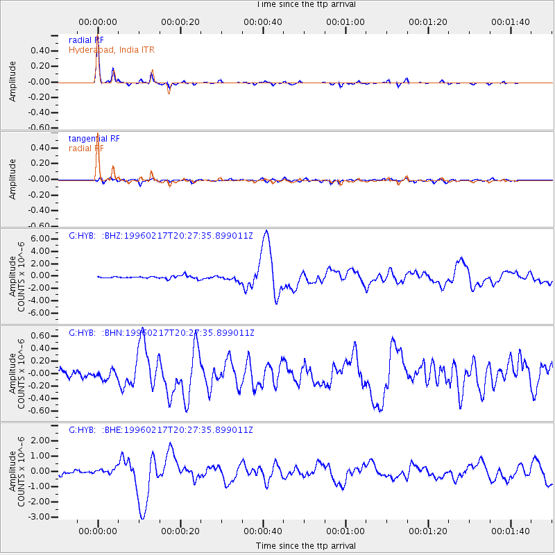
Signal To Noise
| Channel | StoN | STA | LTA |
| G:HYB: :BHN:19960217T20:27:35.899011Z | 1.0828894 | 6.60138E-8 | 6.0960794E-8 |
| G:HYB: :BHE:19960217T20:27:35.899011Z | 2.2337613 | 1.9783447E-7 | 8.856563E-8 |
| G:HYB: :BHZ:19960217T20:27:35.899011Z | 2.254436 | 4.512259E-7 | 2.0015024E-7 |
| Arrivals |
| Ps | 3.8 SECOND |
| PpPs | 14 SECOND |
| PsPs/PpSs | 18 SECOND |


