You are here: Home > Network List > ZJ12 - Transantarctic Mountains Northern Network Stations List
> Station APRL East Antarctica > Earthquake Result Viewer
APRL East Antarctica - Earthquake Result Viewer
| Earthquake location: |
Solomon Islands |
| Earthquake latitude/longitude: |
-6.7/154.9 |
| Earthquake time(UTC): |
2014/04/19 (109) 13:27:59 GMT |
| Earthquake Depth: |
31 km |
| Earthquake Magnitude: |
7.5 MWW, 7.8 MI |
| Earthquake Catalog/Contributor: |
NEIC PDE/NEIC COMCAT |
|
| Network: |
ZJ Transantarctic Mountains Northern Network |
| Station: |
APRL East Antarctica |
| Lat/Lon: |
73.19 S/158.70 E |
| Elevation: |
2258 m |
|
| Distance: |
66.5 deg |
| Az: |
178.804 deg |
| Baz: |
355.913 deg |
| Ray Param: |
0.057560213 |
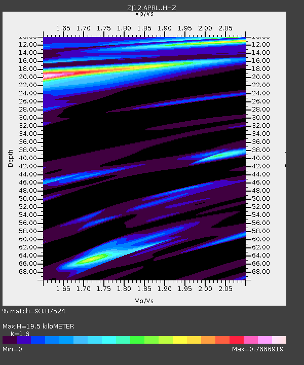
| Estimated Moho Depth: |
19.5 km |
| Estimated Crust Vp/Vs: |
1.60 |
| Assumed Crust Vp: |
6.306 km/s |
| Estimated Crust Vs: |
3.941 km/s |
| Estimated Crust Poisson's Ratio: |
0.18 |
|
| Radial Match: |
93.87524 % |
| Radial Bump: |
400 |
| Transverse Match: |
82.71161 % |
| Transverse Bump: |
400 |
| SOD ConfigId: |
3390531 |
| Insert Time: |
2019-04-11 12:00:26.046 +0000 |
| GWidth: |
2.5 |
| Max Bumps: |
400 |
| Tol: |
0.001 |
|

Signal To Noise
| Channel | StoN | STA | LTA |
| ZJ:APRL: :HHZ:20140419T13:38:15.26001Z | 9.37415 | 3.5631438E-6 | 3.8010313E-7 |
| ZJ:APRL: :HHN:20140419T13:38:15.26001Z | 6.3918505 | 1.6284023E-6 | 2.5476226E-7 |
| ZJ:APRL: :HHE:20140419T13:38:15.26001Z | 0.77988 | 2.95206E-7 | 3.785275E-7 |
| Arrivals |
| Ps | 1.9 SECOND |
| PpPs | 7.7 SECOND |
| PsPs/PpSs | 9.6 SECOND |


