You are here: Home > Network List > AU - Australian Seismological Centre Stations List
> Station MTN Manton Dam, Northern Territory > Earthquake Result Viewer
MTN Manton Dam, Northern Territory - Earthquake Result Viewer
| Earthquake location: |
Hokkaido, Japan Region |
| Earthquake latitude/longitude: |
41.9/142.6 |
| Earthquake time(UTC): |
2011/11/24 (328) 10:25:34 GMT |
| Earthquake Depth: |
38 km |
| Earthquake Magnitude: |
5.9 MB, 5.8 MS, 6.2 MW, 6.2 MW |
| Earthquake Catalog/Contributor: |
WHDF/NEIC |
|
| Network: |
AU Australian Seismological Centre |
| Station: |
MTN Manton Dam, Northern Territory |
| Lat/Lon: |
12.84 S/131.13 E |
| Elevation: |
137 m |
|
| Distance: |
55.5 deg |
| Az: |
193.656 deg |
| Baz: |
10.412 deg |
| Ray Param: |
0.064682916 |
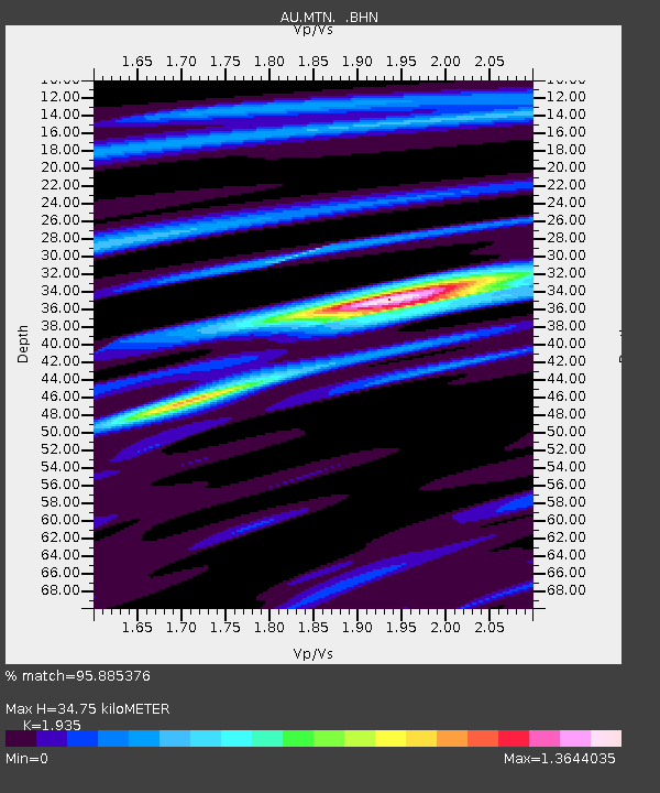
| Estimated Moho Depth: |
34.75 km |
| Estimated Crust Vp/Vs: |
1.93 |
| Assumed Crust Vp: |
6.61 km/s |
| Estimated Crust Vs: |
3.416 km/s |
| Estimated Crust Poisson's Ratio: |
0.32 |
|
| Radial Match: |
95.885376 % |
| Radial Bump: |
242 |
| Transverse Match: |
81.33182 % |
| Transverse Bump: |
400 |
| SOD ConfigId: |
432046 |
| Insert Time: |
2012-03-03 06:57:43.067 +0000 |
| GWidth: |
2.5 |
| Max Bumps: |
400 |
| Tol: |
0.001 |
|

Signal To Noise
| Channel | StoN | STA | LTA |
| AU:MTN: :BHZ:20111124T10:34:34.470002Z | 18.247906 | 1.4281824E-6 | 7.826554E-8 |
| AU:MTN: :BHN:20111124T10:34:34.470002Z | 8.419182 | 1.005668E-6 | 1.1944961E-7 |
| AU:MTN: :BHE:20111124T10:34:34.470002Z | 1.1525581 | 1.2223344E-7 | 1.0605404E-7 |
| Arrivals |
| Ps | 5.2 SECOND |
| PpPs | 15 SECOND |
| PsPs/PpSs | 20 SECOND |


