You are here: Home > Network List > ZJ12 - Transantarctic Mountains Northern Network Stations List
> Station SHRD Lister Nunataks, Antarctica > Earthquake Result Viewer
SHRD Lister Nunataks, Antarctica - Earthquake Result Viewer
| Earthquake location: |
Solomon Islands |
| Earthquake latitude/longitude: |
-6.7/154.9 |
| Earthquake time(UTC): |
2014/04/19 (109) 13:27:59 GMT |
| Earthquake Depth: |
31 km |
| Earthquake Magnitude: |
7.5 MWW, 7.8 MI |
| Earthquake Catalog/Contributor: |
NEIC PDE/NEIC COMCAT |
|
| Network: |
ZJ Transantarctic Mountains Northern Network |
| Station: |
SHRD Lister Nunataks, Antarctica |
| Lat/Lon: |
73.40 S/160.50 E |
| Elevation: |
2457 m |
|
| Distance: |
66.7 deg |
| Az: |
178.26 deg |
| Baz: |
353.978 deg |
| Ray Param: |
0.057393633 |
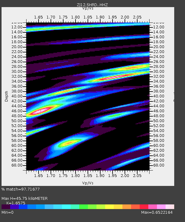
| Estimated Moho Depth: |
45.75 km |
| Estimated Crust Vp/Vs: |
1.66 |
| Assumed Crust Vp: |
6.264 km/s |
| Estimated Crust Vs: |
3.779 km/s |
| Estimated Crust Poisson's Ratio: |
0.21 |
|
| Radial Match: |
97.71677 % |
| Radial Bump: |
400 |
| Transverse Match: |
88.882 % |
| Transverse Bump: |
400 |
| SOD ConfigId: |
3390531 |
| Insert Time: |
2019-04-11 12:00:32.866 +0000 |
| GWidth: |
2.5 |
| Max Bumps: |
400 |
| Tol: |
0.001 |
|

Signal To Noise
| Channel | StoN | STA | LTA |
| ZJ:SHRD: :HHZ:20140419T13:38:16.848999Z | 8.641005 | 3.065554E-6 | 3.5476825E-7 |
| ZJ:SHRD: :HHN:20140419T13:38:16.848999Z | 5.414863 | 1.6081881E-6 | 2.9699515E-7 |
| ZJ:SHRD: :HHE:20140419T13:38:16.848999Z | 0.70511866 | 2.1858847E-7 | 3.100024E-7 |
| Arrivals |
| Ps | 5.0 SECOND |
| PpPs | 19 SECOND |
| PsPs/PpSs | 24 SECOND |


