You are here: Home > Network List > ZJ12 - Transantarctic Mountains Northern Network Stations List
> Station SAMH East Antarctica > Earthquake Result Viewer
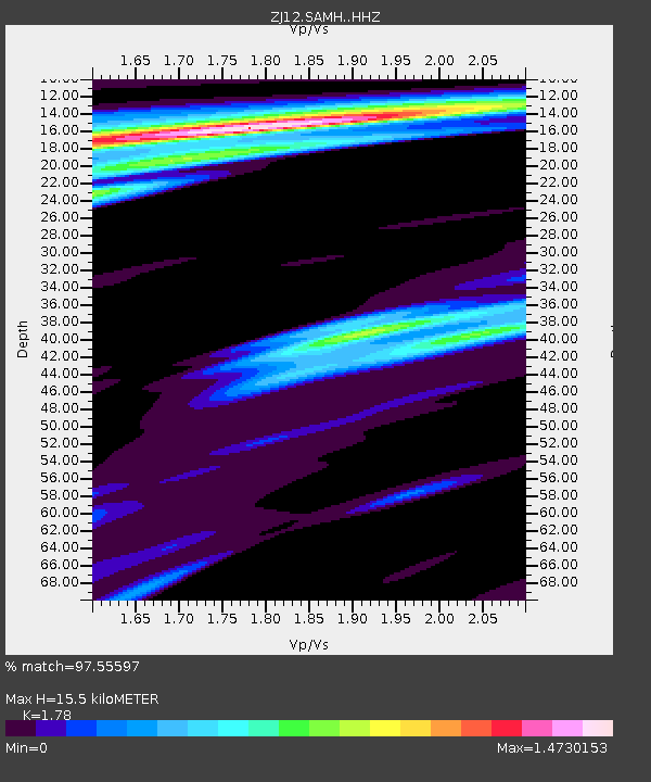
SAMH East Antarctica - Earthquake Result Viewer
| Earthquake location: |
Solomon Islands |
| Earthquake latitude/longitude: |
-6.7/154.9 |
| Earthquake time(UTC): |
2014/04/19 (109) 13:27:59 GMT |
| Earthquake Depth: |
31 km |
| Earthquake Magnitude: |
7.5 MWW, 7.8 MI |
| Earthquake Catalog/Contributor: |
NEIC PDE/NEIC COMCAT |
|
| Network: |
ZJ Transantarctic Mountains Northern Network |
| Station: |
SAMH East Antarctica |
| Lat/Lon: |
75.20 S/154.00 E |
| Elevation: |
2087 m |
|
| Distance: |
68.4 deg |
| Az: |
180.258 deg |
| Baz: |
0.998 deg |
| Ray Param: |
0.056260556 |
| Estimated Moho Depth: |
15.5 km |
| Estimated Crust Vp/Vs: |
1.78 |
| Assumed Crust Vp: |
6.262 km/s |
| Estimated Crust Vs: |
3.518 km/s |
| Estimated Crust Poisson's Ratio: |
0.27 |
|
| Radial Match: |
97.55597 % |
| Radial Bump: |
400 |
| Transverse Match: |
78.528915 % |
| Transverse Bump: |
400 |
| SOD ConfigId: |
3390531 |
| Insert Time: |
2019-04-11 12:00:32.367 +0000 |
| GWidth: |
2.5 |
| Max Bumps: |
400 |
| Tol: |
0.001 |
|

Signal To Noise
| Channel | StoN | STA | LTA |
| ZJ:SAMH: :HHZ:20140419T13:38:27.77002Z | 9.537229 | 4.216233E-6 | 4.4208156E-7 |
| ZJ:SAMH: :HHN:20140419T13:38:27.77002Z | 4.8611107 | 1.313014E-6 | 2.7010574E-7 |
| ZJ:SAMH: :HHE:20140419T13:38:27.77002Z | 1.0021864 | 4.8552306E-7 | 4.844638E-7 |
| Arrivals |
| Ps | 2.0 SECOND |
| PpPs | 6.6 SECOND |
| PsPs/PpSs | 8.6 SECOND |


