You are here: Home > Network List > AZ - ANZA Regional Network Stations List
> Station TMSP TMSP, CA, USA > Earthquake Result Viewer
TMSP TMSP, CA, USA - Earthquake Result Viewer
| Earthquake location: |
Solomon Islands |
| Earthquake latitude/longitude: |
-7.0/154.7 |
| Earthquake time(UTC): |
2014/04/19 (109) 13:31:55 GMT |
| Earthquake Depth: |
41 km |
| Earthquake Magnitude: |
5.8 mb |
| Earthquake Catalog/Contributor: |
ISC/ISC |
|
| Network: |
AZ ANZA Regional Network |
| Station: |
TMSP TMSP, CA, USA |
| Lat/Lon: |
33.62 N/116.68 W |
| Elevation: |
2077 m |
|
| Distance: |
92.7 deg |
| Az: |
56.631 deg |
| Baz: |
263.437 deg |
| Ray Param: |
0.041389283 |
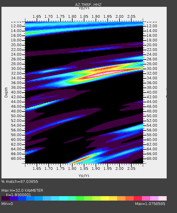
| Estimated Moho Depth: |
32.0 km |
| Estimated Crust Vp/Vs: |
1.93 |
| Assumed Crust Vp: |
6.264 km/s |
| Estimated Crust Vs: |
3.245 km/s |
| Estimated Crust Poisson's Ratio: |
0.32 |
|
| Radial Match: |
87.03855 % |
| Radial Bump: |
273 |
| Transverse Match: |
54.537136 % |
| Transverse Bump: |
400 |
| SOD ConfigId: |
3390531 |
| Insert Time: |
2019-04-11 12:01:39.654 +0000 |
| GWidth: |
2.5 |
| Max Bumps: |
400 |
| Tol: |
0.001 |
|

Signal To Noise
| Channel | StoN | STA | LTA |
| AZ:TMSP: :HHZ:20140419T13:44:31.959016Z | 1.4904351 | 4.9299624E-6 | 3.3077338E-6 |
| AZ:TMSP: :HHN:20140419T13:44:31.959016Z | 1.0580201 | 1.2555377E-6 | 1.186686E-6 |
| AZ:TMSP: :HHE:20140419T13:44:31.959016Z | 0.7918743 | 2.1876342E-6 | 2.762603E-6 |
| Arrivals |
| Ps | 4.8 SECOND |
| PpPs | 15 SECOND |
| PsPs/PpSs | 20 SECOND |


