You are here: Home > Network List > TA - USArray Transportable Network (new EarthScope stations) Stations List
> Station Z46A Louisville, MS, USA > Earthquake Result Viewer
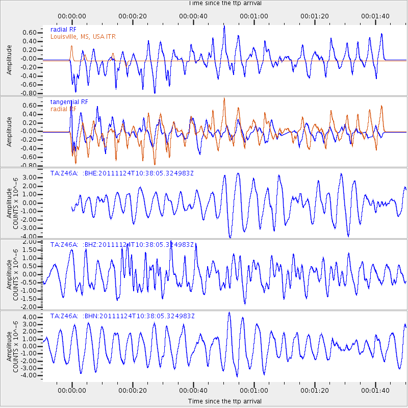
Z46A Louisville, MS, USA - Earthquake Result Viewer
*The percent match for this event was below the threshold and hence no stack was calculated.
| Earthquake location: |
Hokkaido, Japan Region |
| Earthquake latitude/longitude: |
41.9/142.6 |
| Earthquake time(UTC): |
2011/11/24 (328) 10:25:34 GMT |
| Earthquake Depth: |
38 km |
| Earthquake Magnitude: |
5.9 MB, 5.8 MS, 6.2 MW, 6.2 MW |
| Earthquake Catalog/Contributor: |
WHDF/NEIC |
|
| Network: |
TA USArray Transportable Network (new EarthScope stations) |
| Station: |
Z46A Louisville, MS, USA |
| Lat/Lon: |
33.19 N/88.94 W |
| Elevation: |
125 m |
|
| Distance: |
91.5 deg |
| Az: |
41.086 deg |
| Baz: |
324.189 deg |
| Ray Param: |
$rayparam |
*The percent match for this event was below the threshold and hence was not used in the summary stack. |
|
| Radial Match: |
69.89276 % |
| Radial Bump: |
391 |
| Transverse Match: |
68.23893 % |
| Transverse Bump: |
400 |
| SOD ConfigId: |
432046 |
| Insert Time: |
2012-03-03 07:18:31.472 +0000 |
| GWidth: |
2.5 |
| Max Bumps: |
400 |
| Tol: |
0.001 |
|
Signal To Noise
| Channel | StoN | STA | LTA |
| TA:Z46A: :BHZ:20111124T10:38:05.324983Z | 2.6016626 | 1.0346272E-6 | 3.976792E-7 |
| TA:Z46A: :BHN:20111124T10:38:05.324983Z | 1.6650516 | 2.080132E-6 | 1.2492898E-6 |
| TA:Z46A: :BHE:20111124T10:38:05.324983Z | 0.8768223 | 8.848015E-7 | 1.0091002E-6 |
| Arrivals |
| Ps | |
| PpPs | |
| PsPs/PpSs | |


