You are here: Home > Network List > TA - USArray Transportable Network (new EarthScope stations) Stations List
> Station W42A Bald Knob, AR, USA > Earthquake Result Viewer
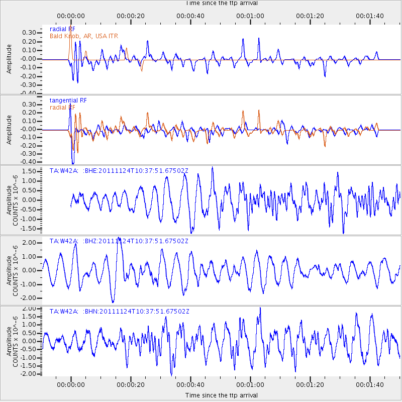
W42A Bald Knob, AR, USA - Earthquake Result Viewer
*The percent match for this event was below the threshold and hence no stack was calculated.
| Earthquake location: |
Hokkaido, Japan Region |
| Earthquake latitude/longitude: |
41.9/142.6 |
| Earthquake time(UTC): |
2011/11/24 (328) 10:25:34 GMT |
| Earthquake Depth: |
38 km |
| Earthquake Magnitude: |
5.9 MB, 5.8 MS, 6.2 MW, 6.2 MW |
| Earthquake Catalog/Contributor: |
WHDF/NEIC |
|
| Network: |
TA USArray Transportable Network (new EarthScope stations) |
| Station: |
W42A Bald Knob, AR, USA |
| Lat/Lon: |
35.27 N/91.52 W |
| Elevation: |
71 m |
|
| Distance: |
88.6 deg |
| Az: |
41.569 deg |
| Baz: |
322.742 deg |
| Ray Param: |
$rayparam |
*The percent match for this event was below the threshold and hence was not used in the summary stack. |
|
| Radial Match: |
54.769028 % |
| Radial Bump: |
400 |
| Transverse Match: |
67.304344 % |
| Transverse Bump: |
400 |
| SOD ConfigId: |
432046 |
| Insert Time: |
2012-03-03 07:20:27.590 +0000 |
| GWidth: |
2.5 |
| Max Bumps: |
400 |
| Tol: |
0.001 |
|
Signal To Noise
| Channel | StoN | STA | LTA |
| TA:W42A: :BHZ:20111124T10:37:51.67502Z | 1.7545828 | 1.0881078E-6 | 6.2015187E-7 |
| TA:W42A: :BHN:20111124T10:37:51.67502Z | 1.0693696 | 3.7482403E-7 | 3.5050937E-7 |
| TA:W42A: :BHE:20111124T10:37:51.67502Z | 2.447687 | 8.197309E-7 | 3.3490022E-7 |
| Arrivals |
| Ps | |
| PpPs | |
| PsPs/PpSs | |


