You are here: Home > Network List > NN - Western Great Basin/Eastern Sierra Nevada Stations List
> Station PRN Pahroc Range, Nevada. (GPS 12/04/2000) w84 > Earthquake Result Viewer
PRN Pahroc Range, Nevada. (GPS 12/04/2000) w84 - Earthquake Result Viewer
| Earthquake location: |
Solomon Islands |
| Earthquake latitude/longitude: |
-7.0/154.7 |
| Earthquake time(UTC): |
2014/04/19 (109) 13:31:55 GMT |
| Earthquake Depth: |
41 km |
| Earthquake Magnitude: |
5.8 mb |
| Earthquake Catalog/Contributor: |
ISC/ISC |
|
| Network: |
NN Western Great Basin/Eastern Sierra Nevada |
| Station: |
PRN Pahroc Range, Nevada. (GPS 12/04/2000) w84 |
| Lat/Lon: |
37.41 N/115.05 W |
| Elevation: |
1464 m |
|
| Distance: |
94.4 deg |
| Az: |
53.004 deg |
| Baz: |
264.606 deg |
| Ray Param: |
0.041028086 |
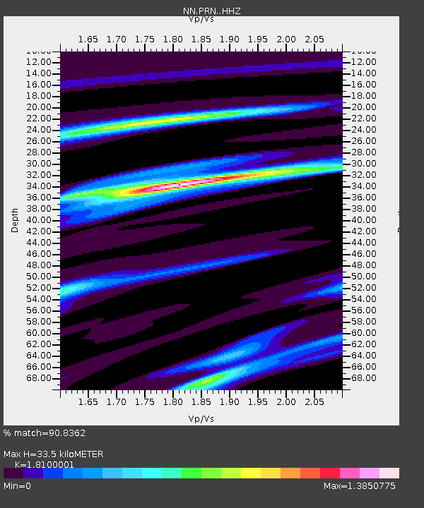
| Estimated Moho Depth: |
33.5 km |
| Estimated Crust Vp/Vs: |
1.81 |
| Assumed Crust Vp: |
6.276 km/s |
| Estimated Crust Vs: |
3.467 km/s |
| Estimated Crust Poisson's Ratio: |
0.28 |
|
| Radial Match: |
90.8362 % |
| Radial Bump: |
278 |
| Transverse Match: |
65.38517 % |
| Transverse Bump: |
400 |
| SOD ConfigId: |
3390531 |
| Insert Time: |
2019-04-11 12:03:32.677 +0000 |
| GWidth: |
2.5 |
| Max Bumps: |
400 |
| Tol: |
0.001 |
|

Signal To Noise
| Channel | StoN | STA | LTA |
| NN:PRN: :HHZ:20140419T13:44:39.814973Z | 4.148801 | 5.7453663E-6 | 1.3848257E-6 |
| NN:PRN: :HHN:20140419T13:44:39.814973Z | 1.1021057 | 6.279526E-7 | 5.697753E-7 |
| NN:PRN: :HHE:20140419T13:44:39.814973Z | 5.119623 | 4.807629E-6 | 9.390592E-7 |
| Arrivals |
| Ps | 4.4 SECOND |
| PpPs | 15 SECOND |
| PsPs/PpSs | 19 SECOND |


