You are here: Home > Network List > G - GEOSCOPE Stations List
> Station INU Inuyama, Japan > Earthquake Result Viewer
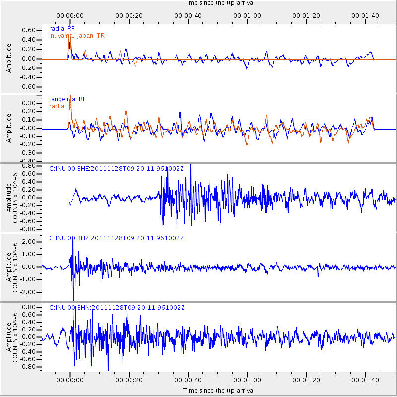
INU Inuyama, Japan - Earthquake Result Viewer
*The percent match for this event was below the threshold and hence no stack was calculated.
| Earthquake location: |
Bali Sea |
| Earthquake latitude/longitude: |
-7.0/117.0 |
| Earthquake time(UTC): |
2011/11/28 (332) 09:13:11 GMT |
| Earthquake Depth: |
616 km |
| Earthquake Magnitude: |
5.9 MB, 5.8 MW, 5.8 MW |
| Earthquake Catalog/Contributor: |
WHDF/NEIC |
|
| Network: |
G GEOSCOPE |
| Station: |
INU Inuyama, Japan |
| Lat/Lon: |
35.35 N/137.03 E |
| Elevation: |
132 m |
|
| Distance: |
46.2 deg |
| Az: |
22.85 deg |
| Baz: |
208.133 deg |
| Ray Param: |
$rayparam |
*The percent match for this event was below the threshold and hence was not used in the summary stack. |
|
| Radial Match: |
59.1504 % |
| Radial Bump: |
400 |
| Transverse Match: |
59.91619 % |
| Transverse Bump: |
400 |
| SOD ConfigId: |
432046 |
| Insert Time: |
2012-03-06 20:47:55.800 +0000 |
| GWidth: |
2.5 |
| Max Bumps: |
400 |
| Tol: |
0.001 |
|
Signal To Noise
| Channel | StoN | STA | LTA |
| G:INU:00:BHZ:20111128T09:20:11.961002Z | 6.7244782 | 7.8429946E-7 | 1.166335E-7 |
| G:INU:00:BHN:20111128T09:20:11.961002Z | 4.034383 | 3.001686E-7 | 7.440261E-8 |
| G:INU:00:BHE:20111128T09:20:11.961002Z | 3.810431 | 2.7917636E-7 | 7.326635E-8 |
| Arrivals |
| Ps | |
| PpPs | |
| PsPs/PpSs | |


