You are here: Home > Network List > TA - USArray Transportable Network (new EarthScope stations) Stations List
> Station H04D Lebanon, OR, USA > Earthquake Result Viewer
H04D Lebanon, OR, USA - Earthquake Result Viewer
| Earthquake location: |
Solomon Islands |
| Earthquake latitude/longitude: |
-7.0/154.7 |
| Earthquake time(UTC): |
2014/04/19 (109) 13:31:55 GMT |
| Earthquake Depth: |
41 km |
| Earthquake Magnitude: |
5.8 mb |
| Earthquake Catalog/Contributor: |
ISC/ISC |
|
| Network: |
TA USArray Transportable Network (new EarthScope stations) |
| Station: |
H04D Lebanon, OR, USA |
| Lat/Lon: |
44.52 N/122.74 W |
| Elevation: |
284 m |
|
| Distance: |
89.6 deg |
| Az: |
45.182 deg |
| Baz: |
259.848 deg |
| Ray Param: |
0.041726828 |
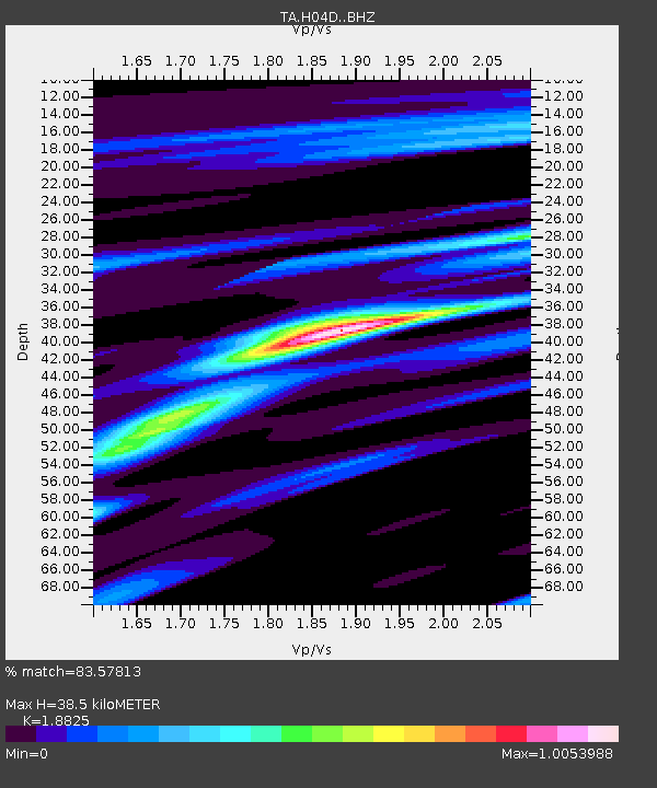
| Estimated Moho Depth: |
38.5 km |
| Estimated Crust Vp/Vs: |
1.88 |
| Assumed Crust Vp: |
6.566 km/s |
| Estimated Crust Vs: |
3.488 km/s |
| Estimated Crust Poisson's Ratio: |
0.30 |
|
| Radial Match: |
83.57813 % |
| Radial Bump: |
399 |
| Transverse Match: |
63.699463 % |
| Transverse Bump: |
400 |
| SOD ConfigId: |
3390531 |
| Insert Time: |
2019-04-11 12:04:30.134 +0000 |
| GWidth: |
2.5 |
| Max Bumps: |
400 |
| Tol: |
0.001 |
|
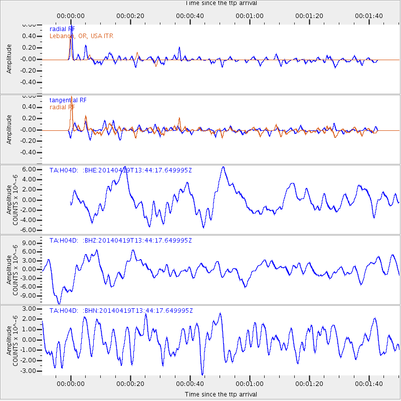
Signal To Noise
| Channel | StoN | STA | LTA |
| TA:H04D: :BHZ:20140419T13:44:17.649995Z | 1.205079 | 4.8996476E-6 | 4.065831E-6 |
| TA:H04D: :BHN:20140419T13:44:17.649995Z | 0.99830645 | 1.2134913E-6 | 1.2155499E-6 |
| TA:H04D: :BHE:20140419T13:44:17.649995Z | 1.0905023 | 2.9826224E-6 | 2.7350907E-6 |
| Arrivals |
| Ps | 5.3 SECOND |
| PpPs | 17 SECOND |
| PsPs/PpSs | 22 SECOND |


