You are here: Home > Network List > AZ - ANZA Regional Network Stations List
> Station FRD AZ.FRD > Earthquake Result Viewer
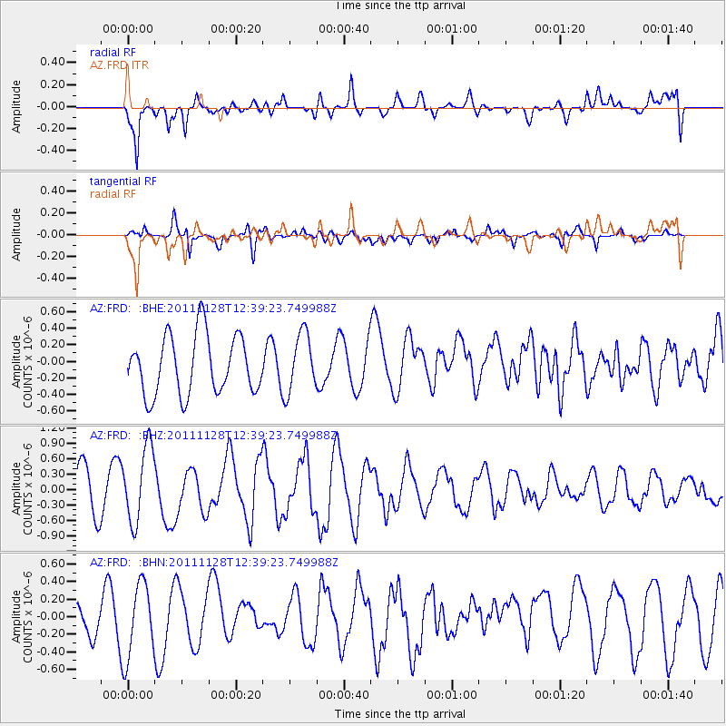
FRD AZ.FRD - Earthquake Result Viewer
*The percent match for this event was below the threshold and hence no stack was calculated.
| Earthquake location: |
New Ireland Region, P.N.G. |
| Earthquake latitude/longitude: |
-5.5/153.7 |
| Earthquake time(UTC): |
2011/11/28 (332) 12:26:45 GMT |
| Earthquake Depth: |
25 km |
| Earthquake Magnitude: |
5.9 MB, 6.0 MS, 6.1 MW, 6.2 MW |
| Earthquake Catalog/Contributor: |
WHDF/NEIC |
|
| Network: |
AZ ANZA Regional Network |
| Station: |
FRD AZ.FRD |
| Lat/Lon: |
33.49 N/116.60 W |
| Elevation: |
1164 m |
|
| Distance: |
92.7 deg |
| Az: |
56.778 deg |
| Baz: |
265.264 deg |
| Ray Param: |
$rayparam |
*The percent match for this event was below the threshold and hence was not used in the summary stack. |
|
| Radial Match: |
59.12706 % |
| Radial Bump: |
400 |
| Transverse Match: |
82.19704 % |
| Transverse Bump: |
400 |
| SOD ConfigId: |
432046 |
| Insert Time: |
2012-03-06 20:53:45.282 +0000 |
| GWidth: |
2.5 |
| Max Bumps: |
400 |
| Tol: |
0.001 |
|
Signal To Noise
| Channel | StoN | STA | LTA |
| AZ:FRD: :BHZ:20111128T12:39:23.749988Z | 1.5737623 | 7.3267717E-7 | 4.6555772E-7 |
| AZ:FRD: :BHN:20111128T12:39:23.749988Z | 2.0472207 | 4.2500517E-7 | 2.0760106E-7 |
| AZ:FRD: :BHE:20111128T12:39:23.749988Z | 0.98894113 | 3.5256613E-7 | 3.565087E-7 |
| Arrivals |
| Ps | |
| PpPs | |
| PsPs/PpSs | |


