You are here: Home > Network List > G - GEOSCOPE Stations List
> Station HYB Hyderabad, India > Earthquake Result Viewer
HYB Hyderabad, India - Earthquake Result Viewer
| Earthquake location: |
Seram, Indonesia |
| Earthquake latitude/longitude: |
-4.0/128.1 |
| Earthquake time(UTC): |
1996/12/30 (365) 19:41:52 GMT |
| Earthquake Depth: |
33 km |
| Earthquake Magnitude: |
6.0 MB, 5.9 MS, 6.2 UNKNOWN, 6.0 MW |
| Earthquake Catalog/Contributor: |
WHDF/NEIC |
|
| Network: |
G GEOSCOPE |
| Station: |
HYB Hyderabad, India |
| Lat/Lon: |
17.42 N/78.55 E |
| Elevation: |
510 m |
|
| Distance: |
53.3 deg |
| Az: |
295.054 deg |
| Baz: |
108.809 deg |
| Ray Param: |
0.06611519 |
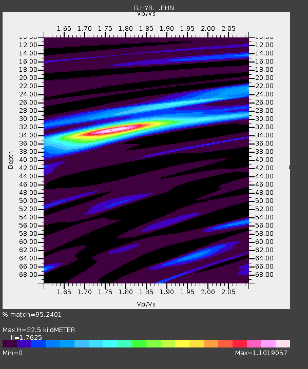
| Estimated Moho Depth: |
32.5 km |
| Estimated Crust Vp/Vs: |
1.76 |
| Assumed Crust Vp: |
6.459 km/s |
| Estimated Crust Vs: |
3.665 km/s |
| Estimated Crust Poisson's Ratio: |
0.26 |
|
| Radial Match: |
95.2401 % |
| Radial Bump: |
333 |
| Transverse Match: |
79.599754 % |
| Transverse Bump: |
400 |
| SOD ConfigId: |
6273 |
| Insert Time: |
2010-02-26 22:54:31.593 +0000 |
| GWidth: |
2.5 |
| Max Bumps: |
400 |
| Tol: |
0.001 |
|

Signal To Noise
| Channel | StoN | STA | LTA |
| G:HYB: :BHN:19961230T19:50:37.250Z | 2.4094892 | 1.1172212E-7 | 4.6367557E-8 |
| G:HYB: :BHE:19961230T19:50:37.250Z | 3.7490346 | 2.3104151E-7 | 6.1626935E-8 |
| G:HYB: :BHZ:19961230T19:50:37.250Z | 7.2881393 | 4.903385E-7 | 6.727897E-8 |
| Arrivals |
| Ps | 4.1 SECOND |
| PpPs | 13 SECOND |
| PsPs/PpSs | 17 SECOND |


