You are here: Home > Network List > TA - USArray Transportable Network (new EarthScope stations) Stations List
> Station L04D Klamath Falls, OR, USA > Earthquake Result Viewer
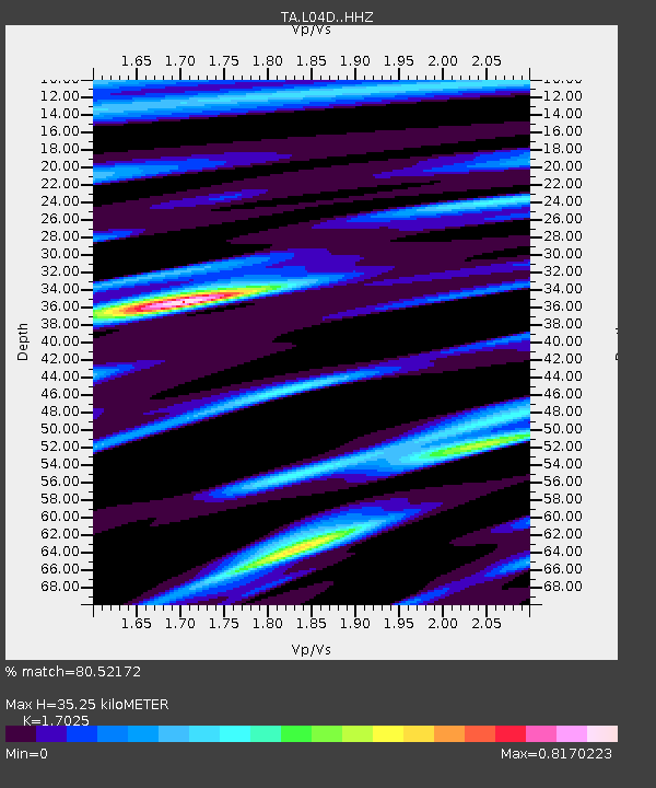
L04D Klamath Falls, OR, USA - Earthquake Result Viewer
| Earthquake location: |
Solomon Islands |
| Earthquake latitude/longitude: |
-7.0/154.7 |
| Earthquake time(UTC): |
2014/04/19 (109) 13:31:55 GMT |
| Earthquake Depth: |
41 km |
| Earthquake Magnitude: |
5.8 mb |
| Earthquake Catalog/Contributor: |
ISC/ISC |
|
| Network: |
TA USArray Transportable Network (new EarthScope stations) |
| Station: |
L04D Klamath Falls, OR, USA |
| Lat/Lon: |
42.22 N/122.30 W |
| Elevation: |
1437 m |
|
| Distance: |
89.5 deg |
| Az: |
47.507 deg |
| Baz: |
260.162 deg |
| Ray Param: |
0.041733168 |
| Estimated Moho Depth: |
35.25 km |
| Estimated Crust Vp/Vs: |
1.70 |
| Assumed Crust Vp: |
6.522 km/s |
| Estimated Crust Vs: |
3.831 km/s |
| Estimated Crust Poisson's Ratio: |
0.24 |
|
| Radial Match: |
80.52172 % |
| Radial Bump: |
400 |
| Transverse Match: |
68.76374 % |
| Transverse Bump: |
400 |
| SOD ConfigId: |
3390531 |
| Insert Time: |
2019-04-11 12:04:34.911 +0000 |
| GWidth: |
2.5 |
| Max Bumps: |
400 |
| Tol: |
0.001 |
|

Signal To Noise
| Channel | StoN | STA | LTA |
| TA:L04D: :HHZ:20140419T13:44:17.230012Z | 0.85894287 | 4.2044912E-6 | 4.8949605E-6 |
| TA:L04D: :HHN:20140419T13:44:17.230012Z | 1.4164312 | 1.289891E-6 | 9.1066266E-7 |
| TA:L04D: :HHE:20140419T13:44:17.230012Z | 2.1174028 | 3.995411E-6 | 1.8869396E-6 |
| Arrivals |
| Ps | 3.9 SECOND |
| PpPs | 14 SECOND |
| PsPs/PpSs | 18 SECOND |


