You are here: Home > Network List > CI - Caltech Regional Seismic Network Stations List
> Station SLA SLA, Trona, CA, USA > Earthquake Result Viewer
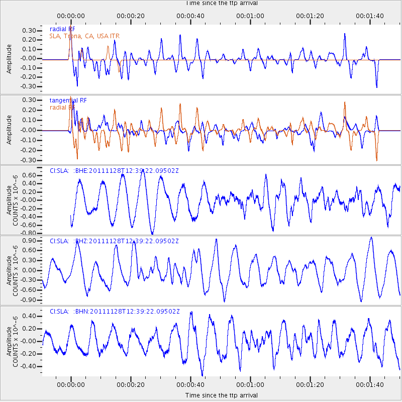
SLA SLA, Trona, CA, USA - Earthquake Result Viewer
*The percent match for this event was below the threshold and hence no stack was calculated.
| Earthquake location: |
New Ireland Region, P.N.G. |
| Earthquake latitude/longitude: |
-5.5/153.7 |
| Earthquake time(UTC): |
2011/11/28 (332) 12:26:45 GMT |
| Earthquake Depth: |
25 km |
| Earthquake Magnitude: |
5.9 MB, 6.0 MS, 6.1 MW, 6.2 MW |
| Earthquake Catalog/Contributor: |
WHDF/NEIC |
|
| Network: |
CI Caltech Regional Seismic Network |
| Station: |
SLA SLA, Trona, CA, USA |
| Lat/Lon: |
35.89 N/117.28 W |
| Elevation: |
1174 m |
|
| Distance: |
92.4 deg |
| Az: |
54.346 deg |
| Baz: |
264.985 deg |
| Ray Param: |
$rayparam |
*The percent match for this event was below the threshold and hence was not used in the summary stack. |
|
| Radial Match: |
82.99389 % |
| Radial Bump: |
400 |
| Transverse Match: |
73.086464 % |
| Transverse Bump: |
400 |
| SOD ConfigId: |
432046 |
| Insert Time: |
2012-03-06 20:54:58.335 +0000 |
| GWidth: |
2.5 |
| Max Bumps: |
400 |
| Tol: |
0.001 |
|
Signal To Noise
| Channel | StoN | STA | LTA |
| CI:SLA: :BHZ:20111128T12:39:22.09502Z | 2.4104621 | 4.742792E-7 | 1.9675862E-7 |
| CI:SLA: :BHN:20111128T12:39:22.09502Z | 0.8386704 | 1.6265479E-7 | 1.9394365E-7 |
| CI:SLA: :BHE:20111128T12:39:22.09502Z | 0.90248644 | 3.602828E-7 | 3.992113E-7 |
| Arrivals |
| Ps | |
| PpPs | |
| PsPs/PpSs | |


