You are here: Home > Network List > G - GEOSCOPE Stations List
> Station HYB Hyderabad, India > Earthquake Result Viewer
HYB Hyderabad, India - Earthquake Result Viewer
| Earthquake location: |
Southern Greece |
| Earthquake latitude/longitude: |
36.4/22.1 |
| Earthquake time(UTC): |
1997/10/13 (286) 13:39:37 GMT |
| Earthquake Depth: |
24 km |
| Earthquake Magnitude: |
6.2 MB, 6.6 MS, 6.7 UNKNOWN, 6.5 MW |
| Earthquake Catalog/Contributor: |
WHDF/NEIC |
|
| Network: |
G GEOSCOPE |
| Station: |
HYB Hyderabad, India |
| Lat/Lon: |
17.42 N/78.55 E |
| Elevation: |
510 m |
|
| Distance: |
53.0 deg |
| Az: |
95.115 deg |
| Baz: |
302.657 deg |
| Ray Param: |
0.066324204 |
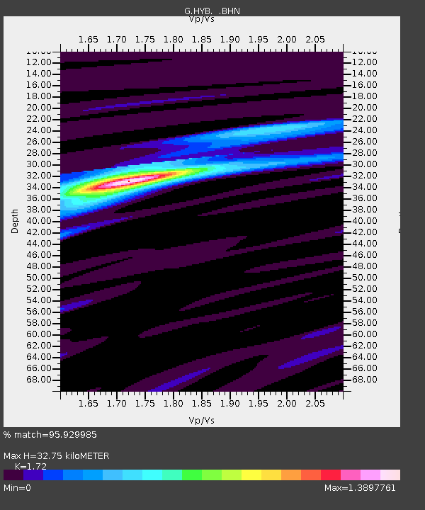
| Estimated Moho Depth: |
32.75 km |
| Estimated Crust Vp/Vs: |
1.72 |
| Assumed Crust Vp: |
6.459 km/s |
| Estimated Crust Vs: |
3.755 km/s |
| Estimated Crust Poisson's Ratio: |
0.24 |
|
| Radial Match: |
95.929985 % |
| Radial Bump: |
316 |
| Transverse Match: |
79.80561 % |
| Transverse Bump: |
400 |
| SOD ConfigId: |
6273 |
| Insert Time: |
2010-02-26 22:54:33.975 +0000 |
| GWidth: |
2.5 |
| Max Bumps: |
400 |
| Tol: |
0.001 |
|
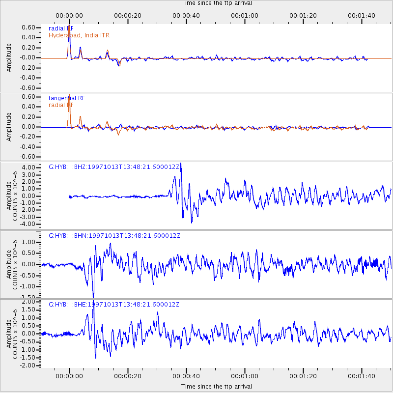
Signal To Noise
| Channel | StoN | STA | LTA |
| G:HYB: :BHN:19971013T13:48:21.600012Z | 1.7272676 | 9.885515E-8 | 5.72321E-8 |
| G:HYB: :BHE:19971013T13:48:21.600012Z | 2.217122 | 1.0777696E-7 | 4.8611202E-8 |
| G:HYB: :BHZ:19971013T13:48:21.600012Z | 3.3294117 | 2.6182659E-7 | 7.86405E-8 |
| Arrivals |
| Ps | 3.9 SECOND |
| PpPs | 13 SECOND |
| PsPs/PpSs | 17 SECOND |


