You are here: Home > Network List > G - GEOSCOPE Stations List
> Station HYB Hyderabad, India > Earthquake Result Viewer
HYB Hyderabad, India - Earthquake Result Viewer
| Earthquake location: |
Flores Region, Indonesia |
| Earthquake latitude/longitude: |
-8.9/123.5 |
| Earthquake time(UTC): |
1997/01/17 (017) 11:20:22 GMT |
| Earthquake Depth: |
111 km |
| Earthquake Magnitude: |
6.2 MB, 6.2 UNKNOWN, 6.2 MW |
| Earthquake Catalog/Contributor: |
WHDF/NEIC |
|
| Network: |
G GEOSCOPE |
| Station: |
HYB Hyderabad, India |
| Lat/Lon: |
17.42 N/78.55 E |
| Elevation: |
510 m |
|
| Distance: |
51.6 deg |
| Az: |
300.509 deg |
| Baz: |
116.914 deg |
| Ray Param: |
0.06695711 |
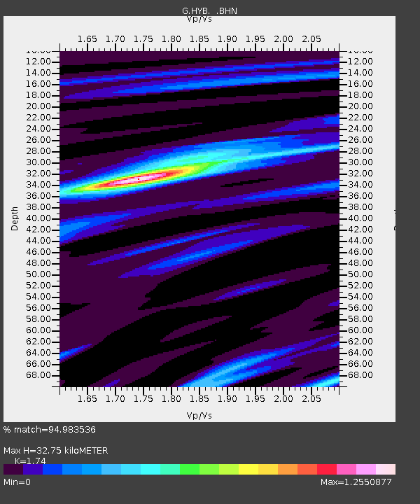
| Estimated Moho Depth: |
32.75 km |
| Estimated Crust Vp/Vs: |
1.74 |
| Assumed Crust Vp: |
6.459 km/s |
| Estimated Crust Vs: |
3.712 km/s |
| Estimated Crust Poisson's Ratio: |
0.25 |
|
| Radial Match: |
94.983536 % |
| Radial Bump: |
291 |
| Transverse Match: |
76.51792 % |
| Transverse Bump: |
400 |
| SOD ConfigId: |
6273 |
| Insert Time: |
2010-02-26 22:54:37.800 +0000 |
| GWidth: |
2.5 |
| Max Bumps: |
400 |
| Tol: |
0.001 |
|
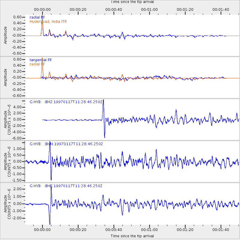
Signal To Noise
| Channel | StoN | STA | LTA |
| G:HYB: :BHN:19970117T11:28:46.250Z | 12.101809 | 5.403162E-7 | 4.4647557E-8 |
| G:HYB: :BHE:19970117T11:28:46.250Z | 16.648138 | 9.20353E-7 | 5.5282634E-8 |
| G:HYB: :BHZ:19970117T11:28:46.250Z | 27.806276 | 2.108808E-6 | 7.583929E-8 |
| Arrivals |
| Ps | 4.0 SECOND |
| PpPs | 13 SECOND |
| PsPs/PpSs | 17 SECOND |


