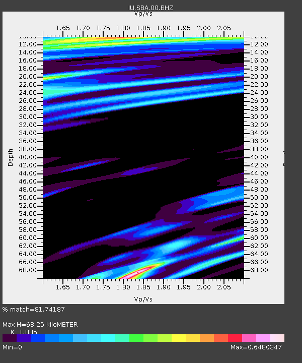
SBA Scott Base, Antarctica - Earthquake Result Viewer
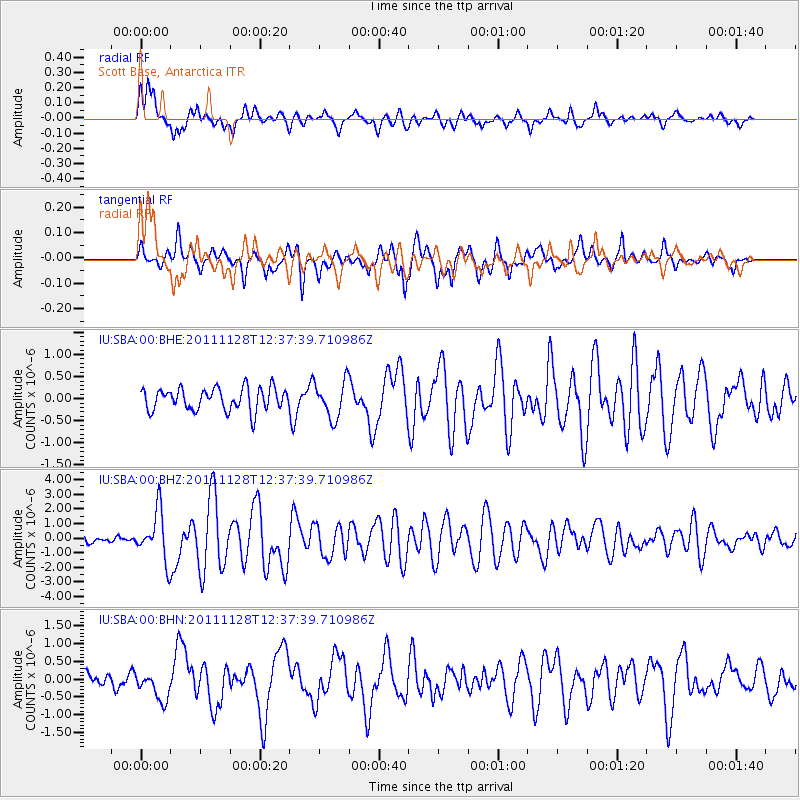
Earthquake location: New Ireland Region, P.N.G.
Earthquake latitude/longitude: -5.5/153.7
Earthquake time(UTC): 2011/11/28 (332) 12:26:45 GMT
Earthquake Depth: 25 km
Earthquake Magnitude: 5.9 MB, 6.0 MS, 6.1 MW, 6.2 MW
Earthquake Catalog/Contributor: WHDF/NEIC
Network: IU Global Seismograph Network (GSN - IRIS/USGS)
Station: SBA Scott Base, Antarctica
Lat/Lon: 77.85 S/166.76 E
Elevation: 50 m
Distance: 72.7 deg
Az: 177.133 deg
Baz: 346.406 deg
Ray Param: 0.05348931
Estimated Moho Depth: 68.25 km
Estimated Crust Vp/Vs: 1.84
Assumed Crust Vp: 6.183 km/s
Estimated Crust Vs: 3.369 km/s
Estimated Crust Poisson's Ratio: 0.29
Radial Match: 81.74187 %
Radial Bump: 400
Transverse Match: 58.066612 %
Transverse Bump: 359
SOD ConfigId: 432046
Insert Time: 2012-03-06 20:56:24.303 +0000
GWidth: 2.5
Max Bumps: 400
Tol: 0.001

Signal To Noise

ChannelStoNSTALTA
IU:SBA:00:BHZ:20111128T12:37:39.710986Z6.20556261.6901924E-62.7236732E-7
IU:SBA:00:BHN:20111128T12:37:39.710986Z1.33520914.0546965E-73.0367502E-7
IU:SBA:00:BHE:20111128T12:37:39.710986Z1.65911264.1842776E-72.5219975E-7
Arrivals
Ps9.5 SECOND
PpPs30 SECOND
PsPs/PpSs40 SECOND