You are here: Home > Network List > UU - University of Utah Regional Network Stations List
> Station PSUT Pine Spring, UT, USA > Earthquake Result Viewer
PSUT Pine Spring, UT, USA - Earthquake Result Viewer
| Earthquake location: |
Solomon Islands |
| Earthquake latitude/longitude: |
-7.0/154.7 |
| Earthquake time(UTC): |
2014/04/19 (109) 13:31:55 GMT |
| Earthquake Depth: |
41 km |
| Earthquake Magnitude: |
5.8 mb |
| Earthquake Catalog/Contributor: |
ISC/ISC |
|
| Network: |
UU University of Utah Regional Network |
| Station: |
PSUT Pine Spring, UT, USA |
| Lat/Lon: |
38.53 N/113.85 W |
| Elevation: |
1999 m |
|
| Distance: |
95.5 deg |
| Az: |
51.961 deg |
| Baz: |
265.429 deg |
| Ray Param: |
0.040754434 |
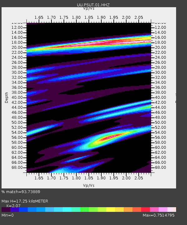
| Estimated Moho Depth: |
17.25 km |
| Estimated Crust Vp/Vs: |
2.07 |
| Assumed Crust Vp: |
6.276 km/s |
| Estimated Crust Vs: |
3.032 km/s |
| Estimated Crust Poisson's Ratio: |
0.35 |
|
| Radial Match: |
93.73889 % |
| Radial Bump: |
400 |
| Transverse Match: |
53.5023 % |
| Transverse Bump: |
400 |
| SOD ConfigId: |
3390531 |
| Insert Time: |
2019-04-11 12:05:16.592 +0000 |
| GWidth: |
2.5 |
| Max Bumps: |
400 |
| Tol: |
0.001 |
|

Signal To Noise
| Channel | StoN | STA | LTA |
| UU:PSUT:01:HHZ:20140419T13:44:44.527986Z | 3.588056 | 1.17297326E-7 | 3.269105E-8 |
| UU:PSUT:01:HHN:20140419T13:44:44.527986Z | 0.6313789 | 1.4897818E-8 | 2.3595685E-8 |
| UU:PSUT:01:HHE:20140419T13:44:44.527986Z | 2.8437085 | 9.677075E-8 | 3.402977E-8 |
| Arrivals |
| Ps | 3.0 SECOND |
| PpPs | 8.3 SECOND |
| PsPs/PpSs | 11 SECOND |


