You are here: Home > Network List > WY - Yellowstone Wyoming Seismic Network Stations List
> Station YHL Hebgen Lake, YNP, WY, USA > Earthquake Result Viewer
YHL Hebgen Lake, YNP, WY, USA - Earthquake Result Viewer
| Earthquake location: |
Solomon Islands |
| Earthquake latitude/longitude: |
-7.0/154.7 |
| Earthquake time(UTC): |
2014/04/19 (109) 13:31:55 GMT |
| Earthquake Depth: |
41 km |
| Earthquake Magnitude: |
5.8 mb |
| Earthquake Catalog/Contributor: |
ISC/ISC |
|
| Network: |
WY Yellowstone Wyoming Seismic Network |
| Station: |
YHL Hebgen Lake, YNP, WY, USA |
| Lat/Lon: |
44.85 N/111.18 W |
| Elevation: |
2691 m |
|
| Distance: |
97.8 deg |
| Az: |
45.736 deg |
| Baz: |
267.924 deg |
| Ray Param: |
0.0400699 |
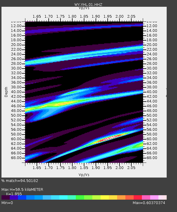
| Estimated Moho Depth: |
59.5 km |
| Estimated Crust Vp/Vs: |
1.96 |
| Assumed Crust Vp: |
6.35 km/s |
| Estimated Crust Vs: |
3.248 km/s |
| Estimated Crust Poisson's Ratio: |
0.32 |
|
| Radial Match: |
94.50182 % |
| Radial Bump: |
340 |
| Transverse Match: |
75.32909 % |
| Transverse Bump: |
400 |
| SOD ConfigId: |
3390531 |
| Insert Time: |
2019-04-11 12:05:45.404 +0000 |
| GWidth: |
2.5 |
| Max Bumps: |
400 |
| Tol: |
0.001 |
|

Signal To Noise
| Channel | StoN | STA | LTA |
| WY:YHL:01:HHZ:20140419T13:44:55.147981Z | 1.4221447 | 6.9025674E-8 | 4.853632E-8 |
| WY:YHL:01:HHN:20140419T13:44:55.147981Z | 1.4511687 | 1.853443E-8 | 1.2772073E-8 |
| WY:YHL:01:HHE:20140419T13:44:55.147981Z | 2.445297 | 5.2468003E-8 | 2.1456701E-8 |
| Arrivals |
| Ps | 9.1 SECOND |
| PpPs | 27 SECOND |
| PsPs/PpSs | 36 SECOND |


