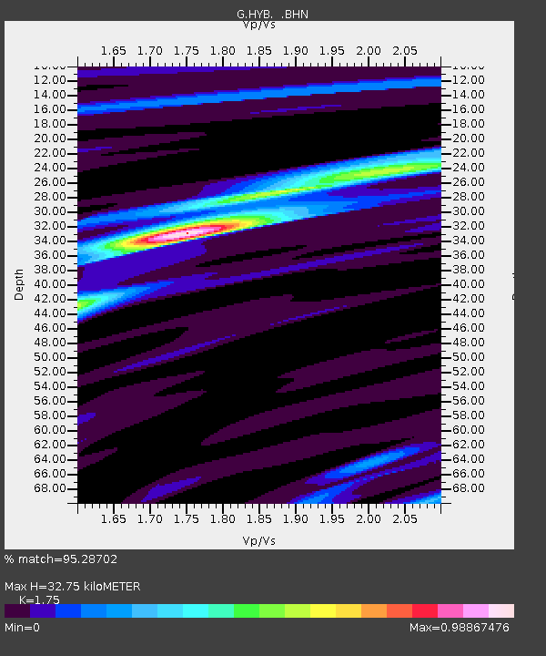
HYB Hyderabad, India - Earthquake Result Viewer

Earthquake location: Minahassa Peninsula, Sulawesi
Earthquake latitude/longitude: 0.2/119.6
Earthquake time(UTC): 1998/05/21 (141) 05:34:25 GMT
Earthquake Depth: 33 km
Earthquake Magnitude: 6.2 MB, 6.3 MS, 6.6 UNKNOWN, 6.6 MW
Earthquake Catalog/Contributor: WHDF/NEIC
Network: G GEOSCOPE
Station: HYB Hyderabad, India
Lat/Lon: 17.42 N/78.55 E
Elevation: 510 m
Distance: 43.8 deg
Az: 295.199 deg
Baz: 108.605 deg
Ray Param: 0.07222153
Estimated Moho Depth: 32.75 km
Estimated Crust Vp/Vs: 1.75
Assumed Crust Vp: 6.459 km/s
Estimated Crust Vs: 3.691 km/s
Estimated Crust Poisson's Ratio: 0.26
Radial Match: 95.28702 %
Radial Bump: 242
Transverse Match: 72.93573 %
Transverse Bump: 400
SOD ConfigId: 4480
Insert Time: 2010-02-26 22:55:09.942 +0000
GWidth: 2.5
Max Bumps: 400
Tol: 0.001

Signal To Noise

ChannelStoNSTALTA
G:HYB: :BHN:19980521T05:41:57.980988Z11.6486221.572256E-61.3497356E-7
G:HYB: :BHE:19980521T05:41:57.980988Z3.30511072.8275826E-78.555183E-8
G:HYB: :BHZ:19980521T05:41:57.980988Z8.8482047.52689E-78.5066866E-8
Arrivals
Ps4.1 SECOND
PpPs13 SECOND
PsPs/PpSs17 SECOND