You are here: Home > Network List > G - GEOSCOPE Stations List
> Station TAM Tamanrasset, Algeria > Earthquake Result Viewer
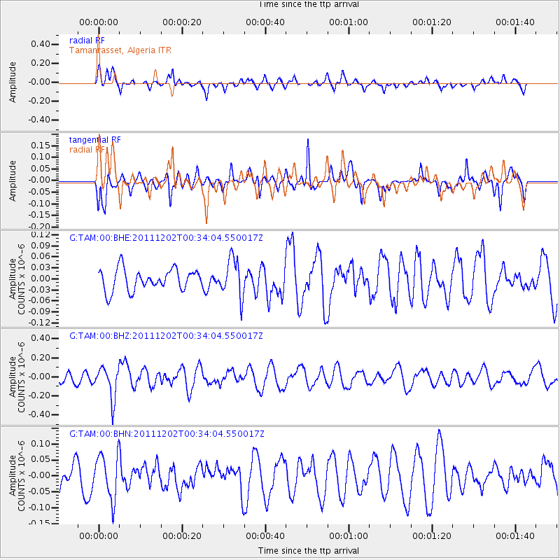
TAM Tamanrasset, Algeria - Earthquake Result Viewer
*The percent match for this event was below the threshold and hence no stack was calculated.
| Earthquake location: |
South Indian Ocean |
| Earthquake latitude/longitude: |
-34.0/58.1 |
| Earthquake time(UTC): |
2011/12/02 (336) 00:22:51 GMT |
| Earthquake Depth: |
10 km |
| Earthquake Magnitude: |
5.7 MB, 5.1 MS, 5.6 MW, 5.4 MW |
| Earthquake Catalog/Contributor: |
WHDF/NEIC |
|
| Network: |
G GEOSCOPE |
| Station: |
TAM Tamanrasset, Algeria |
| Lat/Lon: |
22.79 N/5.53 E |
| Elevation: |
1377 m |
|
| Distance: |
75.4 deg |
| Az: |
310.796 deg |
| Baz: |
137.04 deg |
| Ray Param: |
$rayparam |
*The percent match for this event was below the threshold and hence was not used in the summary stack. |
|
| Radial Match: |
53.325745 % |
| Radial Bump: |
400 |
| Transverse Match: |
44.696537 % |
| Transverse Bump: |
399 |
| SOD ConfigId: |
432046 |
| Insert Time: |
2012-03-06 21:25:29.228 +0000 |
| GWidth: |
2.5 |
| Max Bumps: |
400 |
| Tol: |
0.001 |
|
Signal To Noise
| Channel | StoN | STA | LTA |
| G:TAM:00:BHZ:20111202T00:34:04.550017Z | 1.929922 | 1.6790301E-7 | 8.69999E-8 |
| G:TAM:00:BHN:20111202T00:34:04.550017Z | 1.4661666 | 7.254676E-8 | 4.9480573E-8 |
| G:TAM:00:BHE:20111202T00:34:04.550017Z | 1.8363187 | 5.332859E-8 | 2.9041031E-8 |
| Arrivals |
| Ps | |
| PpPs | |
| PsPs/PpSs | |


