You are here: Home > Network List > G - GEOSCOPE Stations List
> Station HYB Hyderabad, India > Earthquake Result Viewer
HYB Hyderabad, India - Earthquake Result Viewer
| Earthquake location: |
Irian Jaya Region, Indonesia |
| Earthquake latitude/longitude: |
-0.9/136.1 |
| Earthquake time(UTC): |
1996/02/17 (048) 20:17:49 GMT |
| Earthquake Depth: |
33 km |
| Earthquake Magnitude: |
5.7 MB |
| Earthquake Catalog/Contributor: |
WHDF/NEIC |
|
| Network: |
G GEOSCOPE |
| Station: |
HYB Hyderabad, India |
| Lat/Lon: |
17.42 N/78.55 E |
| Elevation: |
510 m |
|
| Distance: |
59.5 deg |
| Az: |
290.788 deg |
| Baz: |
101.733 deg |
| Ray Param: |
0.062087066 |
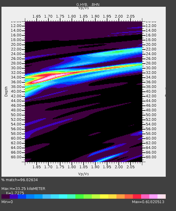
| Estimated Moho Depth: |
33.25 km |
| Estimated Crust Vp/Vs: |
1.73 |
| Assumed Crust Vp: |
6.459 km/s |
| Estimated Crust Vs: |
3.739 km/s |
| Estimated Crust Poisson's Ratio: |
0.25 |
|
| Radial Match: |
96.82634 % |
| Radial Bump: |
223 |
| Transverse Match: |
82.0173 % |
| Transverse Bump: |
400 |
| SOD ConfigId: |
4480 |
| Insert Time: |
2010-02-26 22:55:14.874 +0000 |
| GWidth: |
2.5 |
| Max Bumps: |
400 |
| Tol: |
0.001 |
|

Signal To Noise
| Channel | StoN | STA | LTA |
| G:HYB: :BHN:19960217T20:27:19.100012Z | 2.9946308 | 2.0610548E-7 | 6.8825E-8 |
| G:HYB: :BHE:19960217T20:27:19.100012Z | 1.2120798 | 6.760792E-8 | 5.5778443E-8 |
| G:HYB: :BHZ:19960217T20:27:19.100012Z | 2.843743 | 9.232356E-8 | 3.2465508E-8 |
| Arrivals |
| Ps | 3.9 SECOND |
| PpPs | 13 SECOND |
| PsPs/PpSs | 17 SECOND |


