You are here: Home > Network List > G - GEOSCOPE Stations List
> Station HYB Hyderabad, India > Earthquake Result Viewer
HYB Hyderabad, India - Earthquake Result Viewer

| Earthquake location: |
Talaud Islands, Indonesia |
| Earthquake latitude/longitude: |
2.8/125.2 |
| Earthquake time(UTC): |
1996/03/04 (064) 15:59:05 GMT |
| Earthquake Depth: |
151 km |
| Earthquake Magnitude: |
5.8 MB, 5.9 UNKNOWN, 5.9 MW |
| Earthquake Catalog/Contributor: |
WHDF/NEIC |
|
| Network: |
G GEOSCOPE |
| Station: |
HYB Hyderabad, India |
| Lat/Lon: |
17.42 N/78.55 E |
| Elevation: |
510 m |
|
| Distance: |
48.0 deg |
| Az: |
290.929 deg |
| Baz: |
102.266 deg |
| Ray Param: |
0.069114864 |
| Estimated Moho Depth: |
33.5 km |
| Estimated Crust Vp/Vs: |
1.73 |
| Assumed Crust Vp: |
6.459 km/s |
| Estimated Crust Vs: |
3.739 km/s |
| Estimated Crust Poisson's Ratio: |
0.25 |
|
| Radial Match: |
95.84632 % |
| Radial Bump: |
291 |
| Transverse Match: |
75.5104 % |
| Transverse Bump: |
400 |
| SOD ConfigId: |
4480 |
| Insert Time: |
2010-02-26 22:55:29.855 +0000 |
| GWidth: |
2.5 |
| Max Bumps: |
400 |
| Tol: |
0.001 |
|
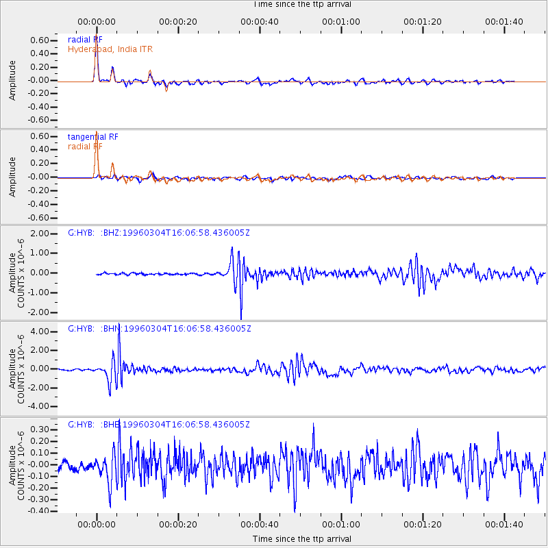
Signal To Noise
| Channel | StoN | STA | LTA |
| G:HYB: :BHN:19960304T16:06:58.436005Z | 19.386728 | 1.0447123E-6 | 5.3888016E-8 |
| G:HYB: :BHE:19960304T16:06:58.436005Z | 3.304328 | 1.2205247E-7 | 3.6937152E-8 |
| G:HYB: :BHZ:19960304T16:06:58.436005Z | 14.459388 | 5.2429596E-7 | 3.62599E-8 |
| Arrivals |
| Ps | 4.0 SECOND |
| PpPs | 13 SECOND |
| PsPs/PpSs | 17 SECOND |


